
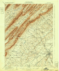
1923 Map of Shippensburg
USGS Topo · Published 1923About this map
Shippensburg sits at the foot of the massive ridge system of the Kittatinny Mountain and Blue Mountain, serving as a critical junction in south-central Pennsylvania. The town is home to the State Normal School and a dense network of local industry and transport, including the Western Maryland railroad line. The landscape is defined by the sharp contrast between the broad agricultural valley and the series of parallel ridges to the northwest, such as Tuscarora Mountain and Amberson Ridge.
Find a feature on this map
112 named features on this map. Tap any name to fly to it.
Don’t see what you’re looking for? This feature index may not catch every label — zoom into the map to look around manually.
Map Details
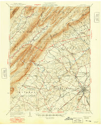
Editions of this 1923 Shippensburg Map
3 editions found
Other maps of this area

1900 · Mercersburg
USGS Topo · 1:62,500

1902 · Chambersburg
USGS Topo · 1:62,500

1902 · Mercersburg
USGS Topo · 1:62,500

1909 · Fairfield
USGS Topo · 1:62,500

1919 · Newville
USGS Topo · 1:62,500

1919 · Mattawana
USGS Topo · 1:62,500

1922 · Mt Union
USGS Topo · 1:48,000

1924 · Mt. Union
USGS Topo · 1:62,500

1930 · Loysville
USGS Topo · 1:62,500

1933 · Loysville
USGS Topo · 1:62,500