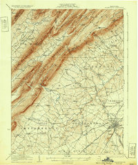
1923 Map of Shippensburg
USGS Topo · Published 1932About this map
The ridge-and-valley landscape of south-central Pennsylvania is meticulously detailed here, centered on the crossroads of Shippensburg and the surrounding agricultural valleys. The State Normal School occupies a prominent position on the edge of the borough, marking the academic anchor of the region. To the northwest, the terrain rises sharply into a series of parallel ridges, including Kittatinny Mountain and Sherman Mountain, which separate Amberson Valley from the fertile lands of Southampton and Hopewell townships.
Find a feature on this map
117 named features on this map. Tap any name to fly to it.
Don’t see what you’re looking for? This feature index may not catch every label — zoom into the map to look around manually.
Map Details
Editions of this 1923 Shippensburg Map
3 editions found
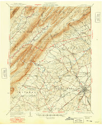
Other maps of this area

1900 · Mercersburg
USGS Topo · 1:62,500

1902 · Chambersburg
USGS Topo · 1:62,500

1902 · Mercersburg
USGS Topo · 1:62,500

1909 · Fairfield
USGS Topo · 1:62,500

1919 · Newville
USGS Topo · 1:62,500

1919 · Mattawana
USGS Topo · 1:62,500

1922 · Mt Union
USGS Topo · 1:48,000

1923 · Shippensburg
USGS Topo · 1:62,500

1924 · Mt. Union
USGS Topo · 1:62,500

1930 · Loysville
USGS Topo · 1:62,500