1950s Maps of Lower Salford Township, Pennsylvania
Explore 6 historic maps of Lower Salford Township from the 1950s. These maps offer a rare glimpse into what life looked like during the 1950s — showing old roads, neighborhoods, homes, and landmarks that have changed or disappeared over time.
Whether you're researching your family's past, planning a metal detecting trip, or studying how Lower Salford Township's landscape evolved across the 1950s, these high-resolution maps are a powerful tool for exploring the history of this region.
- Focus on a specific era: All maps on this page are from the 1950s, giving you a focused view of this time period.
- See what’s changed: Compare century-old streets, trails, and buildings to today's modern landscape using overlays and satellite layers.
- Research with precision: Use these maps for genealogy, historical research, land use analysis, or educational projects.
- View, download, or print: Maps are fully viewable online in high resolution, and can be downloaded or printed for your own records.
Start exploring Lower Salford Township's history through authentic maps from the 1950s. This is your window into the past.
Lower Salford Township, PA maps
(6)- 1951 Map of Collegeville, 1953 Print
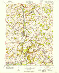 1951 Collegeville1953 Print · USGSMontgomery County was a landscape of historic institutional grounds and creek-side villages in the early fifties. Local historians can trace the footprint of Ursinus College, locate the Eastern State Penitentiary, and find old schools like Henry R Boyer Sch.2 unique versions available
 - 1951 Map of Lansdale, 1953 Print
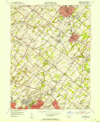 1951 Lansdale1953 Print · USGSPost-war Montgomery County sees the transition from rural townships to growing boroughs as the rail lines hum with activity. Trace the development of Lansdale and North Wales, or find historic sites like Central Schwenkfelder Ch and the Lansdale Airport.2 unique versions available
 - 1953 Map of Telford, 1954 Print
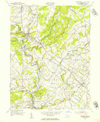
 1953 Telford1954 Print · USGSThe North Penn region comes alive in this mid-century survey, capturing the industrial heart of Souderton and Telford along the Reading railroad. Genealogists can trace family names at Jerusalem Union Ch, Franconia Sch, and the Perkasie Cem.
 - 1953 Map of Perkiomenville, 1954 Print
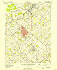
 1953 Perkiomenville1954 Print · USGSCentral Montgomery County thrived as a landscape of rural villages and creekside industry in the early fifties. Genealogists and historians can trace family locations through sites like Old Goshenhoppen Ch, McLeans Station, and Harleysville.2 unique versions available
 - 1956 Map of Newark
 1956 Newark1956 Print · USGSThe industrial heart of the Mid-Atlantic is captured here at the dawn of the highway era, tracing the dense corridors between Newark and Philadelphia. Genealogists and local historians can map the rail networks of the Reading RR or locate mid-century military life at Fort Dix Military Reservation.2 unique versions available
 - 1957 Map of Newark
 1957 Newark1957 Print · USGSThe industrial and military heart of the Mid-Atlantic is mapped during its post-war suburban boom. Genealogists and historians can trace the intricate rail corridors of the Reading Railroad and locate key landmarks from Princeton University to Fort Hancock.
End of results
Showing maps 1-6 of 6
Top cities near Lower Salford Township
- Philadelphia historical maps
- Abington Township historical maps
- Cheltenham Township historical maps
- Norristown historical maps
- Radnor Township historical maps
- Horsham Township historical maps
See more
Top neighborhoods of Lower Salford Township
- Lederach historical maps
- Vernfield historical maps
- Mainland historical maps
- Harleysville historical maps
Frequently asked questions
- What are the different types of historical maps available for Lower Salford Township?
- What is the oldest map of Lower Salford Township?
- Where can I purchase historical maps of Lower Salford Township for my home or office?
- Where can I download high-res historical maps of Lower Salford Township?
- Are there historical topographic maps available for Lower Salford Township?
- Is there historical aerial imagery available for Lower Salford Township?
- Where are historical maps of Lower Salford Township sourced from?