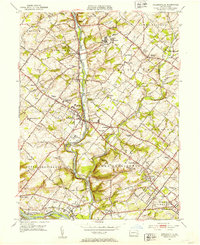
1951 Map of Collegeville
USGS Topo · Published 1953About this map
Perkiomen Creek defines the central axis of this Montgomery County landscape, winding south from Schwenksville toward the Schuylkill River. The early 1950s era shows a region of dense institutional and educational history, anchored by the Ursinus College campus in Collegeville and the expansive grounds of the Eastern State Penitentiary to the north. The map documents a transition from established rural settlements like Skippack and Trappe toward growing suburban pockets, with prominent medical and social facilities including the Eagleville Sanatorium and River Crest Preventorium overlooking the creek valleys.
Find a feature on this map
110 named features on this map. Tap any name to fly to it.
Don’t see what you’re looking for? This feature index may not catch every label — zoom into the map to look around manually.
Map Details
Editions of this 1951 Collegeville Map
2 editions found
Other maps of this area

1888 · Quakertown
USGS Topo · 1:62,500

1890 · Quakertown
USGS Topo · 1:62,500

1894 · Quakertown
USGS Topo · 1:62,500

1894 · Norristown
USGS Topo · 1:62,500

1895 · Norristown
USGS Topo · 1:62,500

1896 · Norristown
USGS Topo · 1:62,500

1902 · Boyertown
USGS Topo · 1:62,500

1906 · Phoenixville
USGS Topo · 1:62,500

1942 · Norristown
USGS Topo · 1:125,000
1943 · Telford
USGS Topo · 1:31,680
Featured Places
- Limerick Township, PA
- Phoenixville, PA
- Skippack Township, PA
- Worcester Township, PA
- Perkiomen Township, PA