1990s Maps of Easton, Pennsylvania
Explore 2 historic maps of Easton from the 1990s. These maps offer a rare glimpse into what life looked like during the 1990s — showing old roads, neighborhoods, homes, and landmarks that have changed or disappeared over time.
Whether you're researching your family's past, planning a metal detecting trip, or studying how Easton's landscape evolved across the 1990s, these high-resolution maps are a powerful tool for exploring the history of this region.
- Focus on a specific era: All maps on this page are from the 1990s, giving you a focused view of this time period.
- See what’s changed: Compare century-old streets, trails, and buildings to today's modern landscape using overlays and satellite layers.
- Research with precision: Use these maps for genealogy, historical research, land use analysis, or educational projects.
- View, download, or print: Maps are fully viewable online in high resolution, and can be downloaded or printed for your own records.
Start exploring Easton's history through authentic maps from the 1990s. This is your window into the past.
Easton, PA maps
(2)- 1999 Map of Easton, 2001 Print
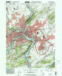 1999 Easton2001 Print · USGSThe tri-city area of Pennsylvania and New Jersey thrives at this river confluence at the turn of the millennium. Researchers can trace the historic Morris Canal, locate family plots at Easton Heights Cemetery, and find old schools like Barber School.
 - 1999 Map of Nazareth, 2002 Print
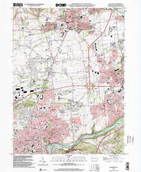 1999 Nazareth2002 Print · USGSIn the Lehigh Valley at the turn of the millennium, Nazareth and the northern reaches of Bethlehem show a mix of colonial Moravian roots and modern industry. Genealogists can trace family sites at Christian Springs or Holy Saviour Cemetery while following the path of the Lehigh Canal.
End of results
Showing maps 1-2 of 2
Top cities near Easton
- Allentown historical maps
- Bethlehem historical maps
- Phillipsburg historical maps
- Lower Saucon Township historical maps
- Hanover Township historical maps
- Center Valley historical maps
See more
Top neighborhoods of Easton
- Paxinosa historical maps
- College Hill historical maps
- West Ward historical maps
- Downtown historical maps
- South Easton historical maps
- Williamsport historical maps
Frequently asked questions
- What are the different types of historical maps available for Easton?
- What is the oldest map of Easton?
- Where can I purchase historical maps of Easton for my home or office?
- Where can I download high-res historical maps of Easton?
- Are there historical topographic maps available for Easton?
- Is there historical aerial imagery available for Easton?
- Where are historical maps of Easton sourced from?