Old Maps of Little Mahanoy Township, Pennsylvania
Explore 46 old maps of Little Mahanoy Township, spanning from 1892 to today. These high-resolution historic maps reveal how streets, neighborhoods, landmarks, and natural features evolved over time — perfect for genealogy, metal detecting, research, and local history exploration.
What you can do with these maps:
- See how Little Mahanoy Township changed over time: Compare historical maps to modern-day views to trace roads, homesites, rail lines & more.
- View detailed metadata: Each map includes creators, publishers, year, scale, and archive source.
- Overlay maps with satellite & LiDAR: Visualize the past alongside modern tools to explore terrain & human change.
- Trusted historical sources: Maps sourced from the USGS, Library of Congress, and other archives.
- Access maps your way: View online, download high-res files, or order prints for personal or research use.
Start exploring old maps of Little Mahanoy Township to uncover forgotten places, hidden landmarks, and the deep history beneath your feet.
Little Mahanoy Township, PA maps
(46)- 1892 Map of Lykens
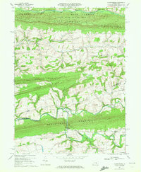
 1892 Lykens1892 Print · USGSDauphin and Schuylkill counties are shown here in the late nineteenth century as the coal and rail industries shaped the valley floors. Genealogists can trace family roots in mining centers like Williamstown and Lykens or agricultural hamlets such as Rough and Ready.2 unique versions available
 - 1892 Map of Shamokin
 1892 Shamokin1892 Print · USGSNorthumberland and Montour Counties are shown here during their industrial prime, when coal and rail shaped every valley. Researchers can trace the early footprints of Shamokin and Danville or locate smaller rail stops like Wolverton Station and Paxinos.
 - 1893 Map of Sunbury
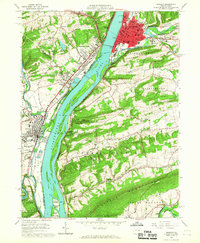
 1893 Sunbury1893 Print · USGSThe Susquehanna River forks define this late nineteenth-century Pennsylvania landscape during a peak era of rail and canal competition. Researchers can trace historic riverfronts at Sunbury and Northumberland or find old family footprints in Selins Grove, Mazeppa, and Freeburg.6 unique versions available
 - 1893 Map of Lykens
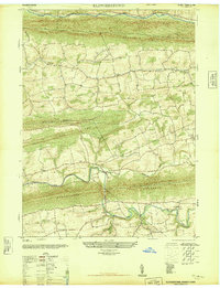
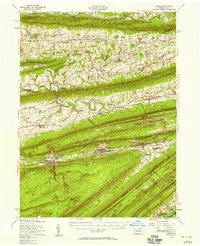
 1893 Lykens1893 Print · USGSThe anthracite coal region of central Pennsylvania comes to life in the late nineteenth century, showing a landscape defined by mountain ridges and mining railways. Local historians can trace the early industrial footprints of Williamstown and Lykens or find rural homesteads near Klingerstown and Leck Kill.7 unique versions available
 - 1893 Map of Shamokin
 1893 Shamokin1893 Print · USGSNorthumberland County's coal-and-rail landscape is captured here during the peak of its industrial development in the late nineteenth century. Researchers can trace the extensive rail networks serving settlements like Shamokin, Danville, and Trevorton, alongside early infrastructure like the Weigh Scale.6 unique versions available
 - 1893 Map of Millersburg
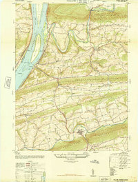
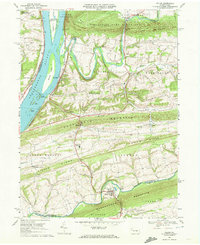
 1893 Millersburg1893 Print · USGSThe Susquehanna River valley in the 1890s shows a landscape shaped by competing transport systems and mountain ridges. Trace the path of the Pennsylvania Canal through Liverpool or locate family roots in Millersburg and Elizabethville.7 unique versions available
 - 1943 Map of Millersburg
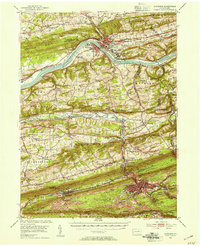
 1943 Millersburg1943 Print · USGSDauphin and Northumberland counties appear here during the mid-1940s, defined by the river-and-rail economy along the Susquehanna River. Researchers can trace the heritage of small valley towns through landmarks like St Johns Church, Morning Glory School, and the Limestone Quarries.
 - 1943 Map of Lykens
 1943 Lykens1943 Print · USGSDauphin and Schuylkill counties are shown in the 1940s as a high-density corridor of anthracite coal production and valley farming. Genealogists and industrial historians can trace the Reading rail lines connecting Williamstown to an Abandoned Colliery and rural landmarks like Himmels Ch.
 - 1943 Map of Shamokin
 1943 Shamokin1943 Print · USGSNorthumberland and Montour Counties were hubs of industry and river trade in the 1940s. Genealogists and historians can trace rail-era landmarks like Wolverton Station and coal-country staples such as the Trevorton Colliery and Zion Church.
 - 1943 Map of Sunbury
 1943 Sunbury1943 Print · USGSDuring the mid-1940s, the Susquehanna River valley functioned as a vital corridor for both higher education and heavy industry. Genealogists can trace family roots through numerous country schools like Ulrich School and landmarks such as Hummels Wharf or the Isle of Que.
 - 1947 Map of Klingerstown
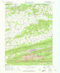
 1947 Klingerstown1947 Print · USGSThe rural borderlands of Northumberland and Schuylkill counties are captured here just after the war. Genealogists can trace family names through landmarks like St Peters-Himmels Church, the Kissingers School, and the village of Rough and Ready.2 unique versions available
 - 1947 Map of Pillow
 1947 Pillow1947 Print · USGSThe river and ridge country of Dauphin and Northumberland Counties comes alive in this post-war survey. Genealogists can trace family roots through numerous local landmarks like Withers School, St Pauls Church, and the riverfront at Port Trevorton.3 unique versions available
 - 1950 Map of Harrisburg, 1952 Print
 1950 Harrisburg1952 Print · USGSMid-century Central Pennsylvania comes alive through its dense rail networks and river valley settlements during the post-war industrial era. Genealogists and historians can trace family roots through hubs like Harrisburg, locate Carlisle Barracks, or follow the Pennsylvania RR through the Lebanon Valley.
 - 1952 Map of Shamokin, 1954 Print
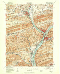
 1952 Shamokin1954 Print · USGSNorthumberland County in the early 1950s shows a landscape defined by the Susquehanna River and the coal-rich ridges of Big Mountain. Genealogists can locate family names at Pine Hill Cem or trace landmarks like the Slovac Academy and Geisinger Hospital.3 unique versions available
 - 1953 Map of Millersburg, 1956 Print
 1953 Millersburg1956 Print · USGSCentral Pennsylvania's river valleys and mountain ridges are captured here during the early fifties, showing a landscape defined by the Susquehanna River. Researchers can locate vanished landmarks like the Abandoned Canal, the Oakdale Sta, and numerous country schools including Keiters Sch.3 unique versions available
 - 1953 Map of Sunbury, 1956 Print
 1953 Sunbury1956 Print · USGSThe Susquehanna River Valley in the early fifties shows a bustling corridor of rail, industry, and academia. Genealogists can trace family names at Stoltzfus Cem, explore the grounds of Bucknell University, or locate the historic Joseph Priestley Home.3 unique versions available
 - 1955 Map of Lykens, 1958 Print
 1955 Lykens1958 Print · USGSThe anthracite coal valleys of Dauphin and Schuylkill counties are shown here in the mid-1950s, a time of transition for the region's industrial landscape. Genealogists can trace family roots through numerous country landmarks like Himmels Ch, Kissingers Sch, and the Pitman Post Office.2 unique versions available
 - 1957 Map of Harrisburg
 1957 Harrisburg1957 Print · USGSMid-century Central Pennsylvania comes into focus as a bustling network of rail, river, and mountain ridges. Genealogists and historians can trace the development of the State Capitol and surrounding hubs like Middletown, Columbia, and Pottsville.7 unique versions available
 - 1961 Map of Harrisburg
 1961 Harrisburg1961 Print · USGSCentral Pennsylvania is shown at a mid-century peak of industrial and military activity, from the Susquehanna water gaps to the fertile Dutch Country. Genealogists and historians can trace the rail corridors of the Pennsylvania RR and find landmarks like Carlisle Barracks or the Anthracite Coal Fields.2 unique versions available
 - 1964 Map of Harrisburg
 1964 Harrisburg1964 Print · USGSCentral Pennsylvania in the mid-fifties reveals a landscape shaped by ridge-and-valley geology and critical Cold War infrastructure. Researchers can trace the massive Indiantown Gap Military Reservation or the rail corridors of the Pennsylvania RR and Reading RR.
 - 1965 Map of Sunbury, 1967 Print
 1965 Sunbury1967 Print · USGSNorthumberland and Snyder counties centered on the Susquehanna River are captured here during a period of steady industrial and educational growth in the mid-sixties. Researchers can find precise locations for Susquehanna University, the historic Fort Augusta, and rural river landings like Fishers Ferry.4 unique versions available
 - 1969 Map of Pillow, 1972 Print
 1969 Pillow1972 Print · USGSThe Susquehanna River and its many islands meet the ridge-and-valley terrain of central Pennsylvania in the late sixties. Genealogists and local historians can trace the rural landscape between Pillow and Port Trevorton, locating Salem Ch, the Penn Central line, and traditional Covered Bridge crossings.2 unique versions available
 - 1969 Map of Trevorton, 1972 Print
 1969 Trevorton1972 Print · USGSNorthumberland County's coal country and rural valleys are captured here in the late sixties, showcasing the intersection of heavy industry and small-town life. Researchers can trace the extensive Strip Mines around Trevorton or locate family sites like St Lukes Cem and Augustaville.2 unique versions available
 - 1969 Map of Klingerstown, 1972 Print
 1969 Klingerstown1972 Print · USGSThe rural valleys between Line Mountain and Mahantango Mountain were captured here in the late sixties. Genealogists and local historians can locate specific family landmarks like Himmels Ch, a Covered Bridge on the creek, and the small settlements of Leck Kill and Rough and Ready.3 unique versions available
 - 1984 Map of Sunbury, 1985 Print
 1984 Sunbury1985 Print · USGSPennsylvania coal country and the Susquehanna valley appear here in the early eighties, showcasing a landscape defined by industrial ridges and river towns. Genealogists and historians can trace rail corridors like Conrail and explore mountain settlements from Mahanoy City to Elizabethville.2 unique versions available
Showing maps 1-25 of 46
Top cities near Little Mahanoy Township
- Sunbury historical maps
- Shamokin historical maps
- Lewisburg historical maps
- Selinsgrove historical maps
- Northumberland historical maps
- Hegins Township historical maps
See more
Top neighborhoods of Little Mahanoy Township
Frequently asked questions
- What are the different types of historical maps available for Little Mahanoy Township?
- What is the oldest map of Little Mahanoy Township?
- Where can I purchase historical maps of Little Mahanoy Township for my home or office?
- Where can I download high-res historical maps of Little Mahanoy Township?
- Are there historical topographic maps available for Little Mahanoy Township?
- Is there historical aerial imagery available for Little Mahanoy Township?
- Where are historical maps of Little Mahanoy Township sourced from?