
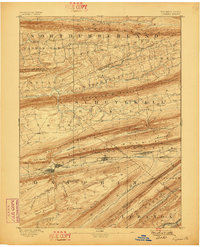
1892 Map of Lykens
USGS Topo · Published 1892About this map
Coal or Thick Mountain dominates the center of this 1889 survey, reflecting the industrial topography of the southern anthracite region. The landscape is defined by long, parallel ridges such as Line Mountain, Mahantango Mountain, and Berry Mountain. Along the valley floor, the Summit Branch Railroad connects a string of mining and industrial settlements, including Lykens, Wiconisco, Williamstown, and Tower City. These towns are tightly clustered at the base of the ridges, following the path of Wiconisco Creek.
Find a feature on this map
80 named features on this map. Tap any name to fly to it.
Don’t see what you’re looking for? This feature index may not catch every label — zoom into the map to look around manually.
Map Details
Editions of this 1892 Lykens Map
2 editions found
Other maps of this area

1889 · Catawissa
USGS Topo · 1:62,500

1891 · Lebanon
USGS Topo · 1:62,500

1892 · Catawissa
USGS Topo · 1:62,500

1892 · Hummelstown
USGS Topo · 1:62,500

1892 · Shamokin
USGS Topo · 1:62,500

1892 · Harrisburg
USGS Topo · 1:62,500

1892 · Pine Grove
USGS Topo · 1:62,500

1893 · Sunbury
USGS Topo · 1:62,500

1893 · Lykens
USGS Topo · 1:62,500

1893 · Lebanon
USGS Topo · 1:62,500