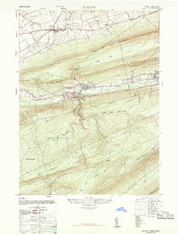
1947 Map of Lykens
USGS Topo · Published 1968About this map
Coal-bearing ridges define the landscape of northern Dauphin County, where the steep slopes of Coal or Thick Mountain and Big Lick Mountain hem in the industrial valley. In the late 1940s, the borough of Lykens and the neighboring settlements of Wiconisco and Williamstown formed a dense corridor of rail and industry along the Reading railroad lines. The presence of the Am Briquet Plant near the valley floor underscores the area's historical reliance on coal processing. North of the ridges, the terrain transitions to a broader agricultural plateau featuring the village of Gratz, the Gratz Airfield, and the County Fair Grounds. This rural section is anchored by local landmarks like Simeons Church and the Salada School, while the southern half of the map is dominated by the wilder, stream-cut drainages of the Haldeman State Forest and the forks of Rattling Creek.
Find a feature on this map
28 named features on this map. Tap any name to fly to it.
Don’t see what you’re looking for? This feature index may not catch every label — zoom into the map to look around manually.
Map Details
Editions of this 1947 Lykens Map
3 editions found
Other maps of this area

1892 · Lykens
USGS Topo · 1:62,500

1892 · Hummelstown
USGS Topo · 1:62,500

1892 · Harrisburg
USGS Topo · 1:62,500

1893 · Lykens
USGS Topo · 1:62,500

1893 · Millersburg
USGS Topo · 1:62,500

1899 · Harrisburg
USGS Topo · 1:62,500

1924 · Hummelstown
USGS Topo · 1:62,500

1924 · Harrisburg
USGS Topo · 1:62,500

1943 · Millersburg
USGS Topo · 1:62,500

1943 · Lykens
USGS Topo · 1:62,500