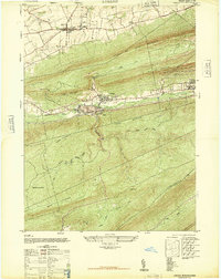
1947 Map of Lykens
USGS Topo · Published 1947About this map
Lykens and Wiconisco anchor this mid-century survey of the northern Dauphin County coal region, where industrial infrastructure meets the steep ridges of the Appalachians. The valley floor is dominated by the extractive economy of the era, marked by the Anthracite Plant and the intricate rail networks of the Reading and Pennsylvania lines that serviced the local collieries. The landscape is defined by massive parallel ridges, including Coal or Thick Mountain and Berry Mountain, which hem in the settlements and the winding course of Wiconisco Creek. To the north, the terrain softens around Gratz, where the County Fair Grounds, Simeons Church, and the small Gratz Airfield indicate a more agricultural character. The southern portion of the map transition into the protected timberlands of the Haldeman State Forest, covering the high ground of Broad Mountain and Peters Mountain.
Find a feature on this map
29 named features on this map. Tap any name to fly to it.
Don’t see what you’re looking for? This feature index may not catch every label — zoom into the map to look around manually.
Map Details
Editions of this 1947 Lykens Map
3 editions found
Other maps of this area

1892 · Lykens
USGS Topo · 1:62,500

1892 · Hummelstown
USGS Topo · 1:62,500

1892 · Harrisburg
USGS Topo · 1:62,500

1893 · Lykens
USGS Topo · 1:62,500

1893 · Millersburg
USGS Topo · 1:62,500

1899 · Harrisburg
USGS Topo · 1:62,500

1924 · Hummelstown
USGS Topo · 1:62,500

1924 · Harrisburg
USGS Topo · 1:62,500

1943 · Millersburg
USGS Topo · 1:62,500

1943 · Lykens
USGS Topo · 1:62,500