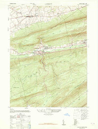
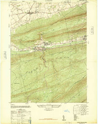
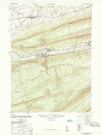
1947 Map of Lykens
USGS Topo · Published 1965About this map
Lykens and Williamstown anchor this mid-century portrait of Pennsylvania’s anthracite country, where industrial development and complex topography define the landscape. The Reading railroad line tracks through the valley parallel to Wiconisco Creek, serving the Anthracite Plant and connecting these vital mining communities. North of the valley, the County Fair Grounds and Gratz Airfield sit near Gratz, while the southern half of the sheet transitions into the steep ridges of Haldeman State Forest. This survey captures the region just after the peak era of coal production, showing the physical footprint of extraction against the natural barriers of Coal or Thick Mountain and Berry Mountain. Notable local landmarks like Simeons Church and Salada School provide specific points of interest for those tracing family history in the upper Dauphin County area.
Find a feature on this map
28 named features on this map. Tap any name to fly to it.
Don’t see what you’re looking for? This feature index may not catch every label — zoom into the map to look around manually.
Map Details
Editions of this 1947 Lykens Map
3 editions found
Other maps of this area

1892 · Lykens
USGS Topo · 1:62,500

1892 · Hummelstown
USGS Topo · 1:62,500

1892 · Harrisburg
USGS Topo · 1:62,500

1893 · Lykens
USGS Topo · 1:62,500

1893 · Millersburg
USGS Topo · 1:62,500

1899 · Harrisburg
USGS Topo · 1:62,500

1924 · Hummelstown
USGS Topo · 1:62,500

1924 · Harrisburg
USGS Topo · 1:62,500

1943 · Millersburg
USGS Topo · 1:62,500

1943 · Lykens
USGS Topo · 1:62,500