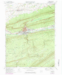
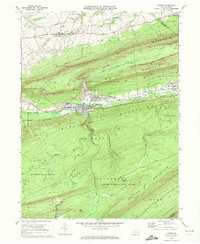
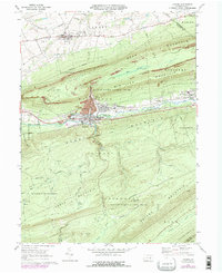
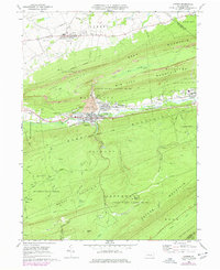
1969 Map of Lykens
USGS Topo · Published 1984About this map
The ridge-and-valley terrain of northern Dauphin County is defined here by the industrial and social hubs of Lykens and Wiconisco. Situated between the steep slopes of Big Lick Mountain and Berry Mountain, these communities show the deep imprint of coal heritage, with strip mines and a Tailings Pond visible on the mountainside. The map captures a transition in local life, documenting traditional gathering places like the Fairground and Drive-in Theater near Gratz alongside mid-century infrastructure like the Flying Eagles Airfield. Large tracts of the southern landscape are preserved as Haldeman State Forest and State Game Lands No 210, where numerous named waterways like Lykens Run and Nine O'Clock Run drain into the Wiconisco Creek valley.
Find a feature on this map
59 named features on this map. Tap any name to fly to it.
Don’t see what you’re looking for? This feature index may not catch every label — zoom into the map to look around manually.
Map Details
Editions of this 1969 Lykens Map
4 editions found
Other maps of this area

1892 · Lykens
USGS Topo · 1:62,500

1892 · Hummelstown
USGS Topo · 1:62,500

1892 · Harrisburg
USGS Topo · 1:62,500

1893 · Lykens
USGS Topo · 1:62,500

1893 · Millersburg
USGS Topo · 1:62,500

1899 · Harrisburg
USGS Topo · 1:62,500

1924 · Hummelstown
USGS Topo · 1:62,500

1924 · Harrisburg
USGS Topo · 1:62,500

1943 · Millersburg
USGS Topo · 1:62,500

1943 · Lykens
USGS Topo · 1:62,500