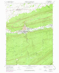
1969 Map of Lykens
USGS Topo · Published 1977About this map
The northern edge of the coal regions in Dauphin County is defined by the heavy industrial and mountain landscape surrounding Lykens and Wiconisco. By the late 1960s, the terrain of Short Mountain and Bear Mountain shows extensive evidence of the anthracite era, with numerous Strip Mines and a large Tailings Pond bordering Wiconisco Creek. The valley floor is tightly packed with residential blocks and civic infrastructure, including the Wiconisco Sch and Calvary Ch, while the northern plateau near Gratz maintains a more open character featuring a Drive-in Theater, Fairgrounds, and the Flying Eagles Airfield. Large tracts of protected land, such as State Game Lands No 264 and Haldeman State Forest, cover the ridges, where numerous runs like Rattling Creek and Doc Smith Run carve deep gaps into the sandstone heights. These wooded slopes separate the industrial valley from the agricultural expanses of Hubley and Jefferson townships.
Find a feature on this map
64 named features on this map. Tap any name to fly to it.
Don’t see what you’re looking for? This feature index may not catch every label — zoom into the map to look around manually.
Map Details
Editions of this 1969 Lykens Map
4 editions found
Other maps of this area

1892 · Lykens
USGS Topo · 1:62,500

1892 · Hummelstown
USGS Topo · 1:62,500

1892 · Harrisburg
USGS Topo · 1:62,500

1893 · Lykens
USGS Topo · 1:62,500

1893 · Millersburg
USGS Topo · 1:62,500

1899 · Harrisburg
USGS Topo · 1:62,500

1924 · Hummelstown
USGS Topo · 1:62,500

1924 · Harrisburg
USGS Topo · 1:62,500

1943 · Millersburg
USGS Topo · 1:62,500

1943 · Lykens
USGS Topo · 1:62,500