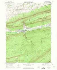
1969 Map of Lykens
USGS Topo · Published 1972About this map
Wiconisco Creek winds through a narrow valley defined by steep ridges in this central Pennsylvania coal region. The town of Lykens serves as a central hub, flanked by Wiconisco and Dayton along the Penn Central rail line. The landscape reflects a mix of industrial activity and recreation, featuring several Strip Mines and Tailings Ponds alongside modern mid-century landmarks like the Drive-in Theater and Flying Eagles Airfield. Large tracts of State Game Lands No 264 and the Haldeman State Forest occupy the surrounding mountains, where local landmarks like Spechty Kopf and Bear Puddles define the high ground. To the north, the borough of Gratz sits on more level terrain, anchored by its local Fairground, illustrating the sharp transition from the industrial valley floor to the agricultural and recreational uplands.
Find a feature on this map
70 named features on this map. Tap any name to fly to it.
Don’t see what you’re looking for? This feature index may not catch every label — zoom into the map to look around manually.
Map Details
Editions of this 1969 Lykens Map
4 editions found
Other maps of this area

1892 · Lykens
USGS Topo · 1:62,500

1892 · Hummelstown
USGS Topo · 1:62,500

1892 · Harrisburg
USGS Topo · 1:62,500

1893 · Lykens
USGS Topo · 1:62,500

1893 · Millersburg
USGS Topo · 1:62,500

1899 · Harrisburg
USGS Topo · 1:62,500

1924 · Hummelstown
USGS Topo · 1:62,500

1924 · Harrisburg
USGS Topo · 1:62,500

1943 · Millersburg
USGS Topo · 1:62,500

1943 · Lykens
USGS Topo · 1:62,500