1960s Maps of Southwest Madison Township, Pennsylvania
Explore 4 historic maps of Southwest Madison Township from the 1960s. These maps offer a rare glimpse into what life looked like during the 1960s — showing old roads, neighborhoods, homes, and landmarks that have changed or disappeared over time.
Whether you're researching your family's past, planning a metal detecting trip, or studying how Southwest Madison Township's landscape evolved across the 1960s, these high-resolution maps are a powerful tool for exploring the history of this region.
- Focus on a specific era: All maps on this page are from the 1960s, giving you a focused view of this time period.
- See what’s changed: Compare century-old streets, trails, and buildings to today's modern landscape using overlays and satellite layers.
- Research with precision: Use these maps for genealogy, historical research, land use analysis, or educational projects.
- View, download, or print: Maps are fully viewable online in high resolution, and can be downloaded or printed for your own records.
Start exploring Southwest Madison Township's history through authentic maps from the 1960s. This is your window into the past.
Southwest Madison Township, PA maps
(4)- 1960 Map of Mc Coysville, 1962 Print
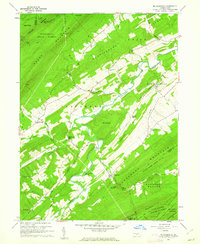 1960 Mc Coysville1962 Print · USGSJuniata County in the early sixties remains a landscape of traditional crossroads and mountain gaps. Genealogists can trace family footprints at McCullochs Mills, McCoysville Cem, and the small settlement of Honey Grove.3 unique versions available
 - 1960 Map of Blain, 1963 Print
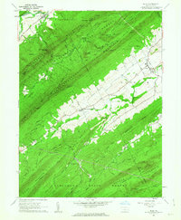 1960 Blain1963 Print · USGSPerry County saw its rural landscape and small-town centers well-established by the early sixties. Researchers can trace family history through Three Springs Ch, locate the cemetery near Blain, and explore mountain gaps like Winns Gap.4 unique versions available
 - 1961 Map of Harrisburg
 1961 Harrisburg1961 Print · USGSCentral Pennsylvania is shown at a mid-century peak of industrial and military activity, from the Susquehanna water gaps to the fertile Dutch Country. Genealogists and historians can trace the rail corridors of the Pennsylvania RR and find landmarks like Carlisle Barracks or the Anthracite Coal Fields.2 unique versions available
 - 1964 Map of Harrisburg
 1964 Harrisburg1964 Print · USGSCentral Pennsylvania in the mid-fifties reveals a landscape shaped by ridge-and-valley geology and critical Cold War infrastructure. Researchers can trace the massive Indiantown Gap Military Reservation or the rail corridors of the Pennsylvania RR and Reading RR.
End of results
Showing maps 1-4 of 4
Top cities near Southwest Madison Township
- Carlisle historical maps
- Dickinson historical maps
- Granville Township historical maps
- Saville Township historical maps
- Centre historical maps
- Lurgan Township historical maps
See more
Top neighborhoods of Southwest Madison Township
- Couchtown historical maps
- Stony Point historical maps
- Cisna Run historical maps
- Andersonburg historical maps
- Centre historical maps
Frequently asked questions
- What are the different types of historical maps available for Southwest Madison Township?
- What is the oldest map of Southwest Madison Township?
- Where can I purchase historical maps of Southwest Madison Township for my home or office?
- Where can I download high-res historical maps of Southwest Madison Township?
- Are there historical topographic maps available for Southwest Madison Township?
- Is there historical aerial imagery available for Southwest Madison Township?
- Where are historical maps of Southwest Madison Township sourced from?