1900s (20th Century) Maps of Highland Acres, Delaware Township
Explore 11 historic maps of Highland Acres from the 1900s (20th Century). These maps offer a rare glimpse into what life looked like during the 1900s — showing old roads, neighborhoods, homes, and landmarks that have changed or disappeared over time.
Whether you're researching your family's past, planning a metal detecting trip, or studying how Highland Acres's landscape evolved across the 1900s, these high-resolution maps are a powerful tool for exploring the history of this region.
- Focus on a specific era: All maps on this page are from the 1900s, giving you a focused view of this time period.
- See what’s changed: Compare century-old streets, trails, and buildings to today's modern landscape using overlays and satellite layers.
- Research with precision: Use these maps for genealogy, historical research, land use analysis, or educational projects.
- View, download, or print: Maps are fully viewable online in high resolution, and can be downloaded or printed for your own records.
Start exploring Highland Acres's history through authentic maps from the 1900s. This is your window into the past.
Highland Acres, Delaware Township maps
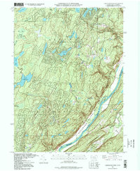
(11)- 1943 Map of Lake Maskenozha
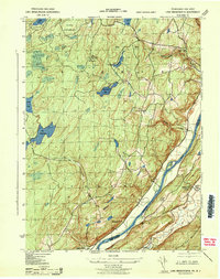 1943 Lake Maskenozha1943 Print · USGSThe Delaware River valley at the height of the war years is documented here in detail, showing the borderlands of Pike County and Sussex County. Genealogists and local historians can trace old homesteads and landmarks like Wallpack Center, Egypt Mills, and the Wallpack Center School.3 unique versions available
 - 1950 Map of Scranton, 1952 Print
 1950 Scranton1952 Print · USGSMid-century Northeast Pennsylvania and the Hudson Valley come alive in this survey of the tri-state region. Genealogists and historians can trace the dense rail networks of the Erie RR and DL&W RR between industrial hubs like Scranton and Wilkes-Barre.
 - 1953 Map of Scranton
 1953 Scranton1953 Print · USGSNortheastern Pennsylvania and the Catskills are shown in great detail during the early fifties, a time when rail lines and river valleys dictated the region's growth. Genealogists and historians can trace the industrial hearts of Scranton and Wilkes-Barre or locate remote landmarks like High Point and Lake Wallenpaupack.
 - 1954 Map of Lake Maskenozha, 1955 Print
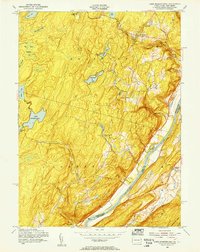 1954 Lake Maskenozha1955 Print · USGSThe Delaware River valley thrived as a hub for summer camps and small riverfront communities in the mid-1950s. Genealogists and local historians can trace legacy sites like Wallpack Center, Egypt Mills, and the Holy Trinity Ch near the New Jersey border.5 unique versions available
 - 1954 Map of Dingmans Ferry, 1960 Print
 1954 Dingmans Ferry1960 Print · USGSSussex County, New Jersey, and the Delaware River valley are captured here in the mid-fifties, just as the region’s recreation economy was at its peak. Genealogists and historians can trace the foundations of Stillwater and Branchville, or locate remote landmarks like Wallpack Center and Millbrook.2 unique versions available
 - 1959 Map of Scranton
 1959 Scranton1959 Print · USGSThe northern coalfields and the Hudson Valley meet in this mid-century survey of the Pennsylvania and New York borderlands. Genealogists and historians can trace the intricate rail networks of the Erie Railroad and the vast waters of Lake Wallenpaupack.2 unique versions available
 - 1962 Map of Scranton, 1977 Print
 1962 Scranton1977 Print · USGSThe industrial heart of eastern Pennsylvania and the New York Catskills are captured here in the early sixties. Genealogists and historians can trace the dense valley settlements from Scranton to Wilkes-Barre and the rail lines of the Erie Lackawanna Railroad.2 unique versions available
 - 1965 Map of Scranton
 1965 Scranton1965 Print · USGSThe tri-state highlands of Pennsylvania, New York, and New Jersey come alive in the mid-sixties as industry and recreation converge. Trace the intricate rail lines of the Erie Lackawanna RR or locate landmarks like the U S Military Academy.2 unique versions available
 - 1986 Map of Middletown
 1986 Middletown1986 Print · USGSThe Tri-State region comes alive in the mid-1980s, documenting the corridor from the Hudson River to the Delaware Water Gap. Researchers can trace the sprawling grounds of West Point, the extensive Conrail rail network, and early suburban growth around Middletown and Suffern.2 unique versions available
 - 1994 Map of Lake Maskenozha, 1995 Print
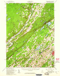
 1994 Lake Maskenozha1995 Print · USGSThe Pennsylvania-New Jersey borderlands in the mid-1990s show a mix of protected state forests and summer camps. Researchers can trace historic sites like Egypt Mills, find old structures at Wallpack Center, and locate natural landmarks including Dingmans Falls and Shapnack Island.
 - 1995 Map of Lake Maskenozha, 1998 Print
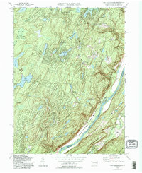
 1995 Lake Maskenozha1998 Print · USGSPike County and the Delaware River valley are shown in the 1990s as a haven for summer camps and state forest land. Researchers can locate early industrial sites like Haney's Mill and landmarks such as Holy Trinity Ch or Wallpack Center.
End of results
Showing maps 1-11 of 11
Frequently asked questions
- What are the different types of historical maps available for Highland Acres?
- What is the oldest map of Highland Acres?
- Where can I purchase historical maps of Highland Acres for my home or office?
- Where can I download high-res historical maps of Highland Acres?
- Are there historical topographic maps available for Highland Acres?
- Is there historical aerial imagery available for Highland Acres?
- Where are historical maps of Highland Acres sourced from?