Old Maps of Homer Township, Pennsylvania for Genealogy
Trace your family roots with 19 historic maps of Homer Township. These high-res maps reveal old neighborhoods, homesites, landmarks, and streets — helping you uncover where your ancestors lived and how the area evolved over time.
- Explore historic neighborhoods: Identify where your relatives may have lived in the 1800s or 1900s.
- Compare maps over time: Trace the changes in streets, buildings, and landmarks for multi-generational research.
- Perfect for genealogy & ancestry research: Used by family historians and researchers to map out lineage and migration.
These maps are an incredible resource for exploring your personal connection to Homer Township's past.
Homer Township, PA maps
(19)- 1947 Map of Conrad, 1952 Print
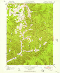
 1947 Conrad1952 Print · USGSPotter County’s timbered ridges and deep hollows are captured here just after the war, showing a rural landscape before modern development. Researchers can locate family cemeteries like Angell Cem and Reed Cem, or trace the old Jersey Shore Turnpike.4 unique versions available
 - 1947 Map of Ayers Hill, 1957 Print
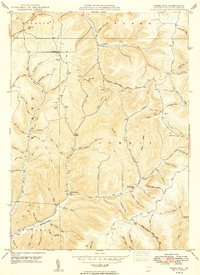
 1947 Ayers Hill1957 Print · USGSPotter County’s high ridges and deep hollows are captured here just after the war, showing a landscape defined by old family settlements and emerging recreation. Genealogists and hikers can trace early routes like the Coudersport Jersey Shore Turnpike or locate family sites like Anson Cem and the United Brethren Ch.3 unique versions available
 - 1948 Map of Emporium, 1952 Print
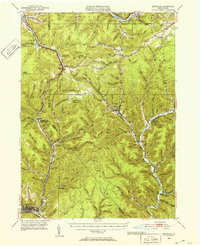 1948 Emporium1952 Print · USGSThe northern Pennsylvania highlands come into focus in the late 1940s, showing a network of mountain settlements and headwater streams. You can trace family roots at Wharton Cem and St Marks Cem or locate old schoolhouse sites like Reesville Sch.3 unique versions available
 - 1948 Map of Austin, 1965 Print
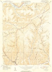
 1948 Austin1965 Print · USGSThe valley of the Allegheny River and the settlement of Austin are shown here in the late 1940s. Genealogists and local historians can trace family-named landmarks like Cochrane Hol and find rural infrastructure such as the Inez Sch.4 unique versions available
 - 1949 Map of Ayers Hill
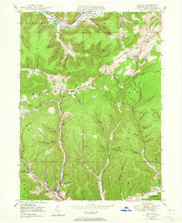
 1949 Ayers Hill1949 Print · USGSPotter County’s wooded highlands appear here just after the war, showing the network of rural mountain roads and small hollows that shaped local life. Genealogists can locate family landmarks like Ayers Hill Cem, Borie, and the United Brethren Ch.2 unique versions available
 - 1950 Map of Austin
 1950 Austin1950 Print · USGSPotter County's deep-cut valleys and timbered ridges are captured here at mid-century as the local economy transitioned toward modern energy and infrastructure. Genealogists and historians can trace family-named hollows and vanished landmarks like the Inez Sch, the riverside hamlet of Mina, and the industrial footprint of Austin.2 unique versions available
 - 1954 Map of Williamsport
 1954 Williamsport1954 Print · USGSNorth-central Pennsylvania in the mid-fifties is defined by the winding West Branch Susquehanna River and its industrial valley. Local historians can trace the massive Susquehanna Ordnance Depot and the extensive rail networks of the Pennsylvania Railroad.
 - 1957 Map of Warren, 1964 Print
 1957 Warren1964 Print · USGSThe northern Pennsylvania oil and timber country comes into focus in the mid-fifties, showing the region before modern highway expansions. Trace the industrial rail networks of the Pennsylvania RR and the early Allegheny River Reservoir near Warren and Oil City.4 unique versions available
 - 1958 Map of Warren
 1958 Warren1958 Print · USGSNorthern Pennsylvania’s timber and oil country is captured here during the late fifties, showing the interplay of industrial valleys and vast state forests. Genealogists can trace family connections across the Cornplanter Indian Reservation or through rail hubs like Oil City and Saint Marys.
 - 1959 Map of Warren
 1959 Warren1959 Print · USGSNorthern Pennsylvania's oil and timber country comes alive in this late-fifties study of the forest-clad plateaus. Trace the historic Cornplanter (Indian Reservation), the sprawling Oil Field, and the rail lines of the Pennsylvania RR.2 unique versions available
 - 1960 Map of Williamsport
 1960 Williamsport1960 Print · USGSNorth-central Pennsylvania in the mid-twentieth century was a vital corridor of rail and river industry stretching from the New York line to the coal regions. Genealogists can trace the rail networks of the Pennsylvania RR and Lehigh Valley RR connecting towns like Williamsport, Towanda, and Lock Haven.
 - 1962 Map of Williamsport, 1966 Print
 1962 Williamsport1966 Print · USGSNorth-central Pennsylvania was a landscape of industrial river hubs and vast state woodlands in the early sixties. Researchers can trace the path of the Pennsylvania Railroad through Williamsport and explore the remote reaches of Bucktail State Park.5 unique versions available
 - 1965 Map of Williamsport
 1965 Williamsport1965 Print · USGSNorth-central Pennsylvania in the mid-1960s is defined by the industrial river towns and vast timberlands of the Allegheny Plateau. Researchers can trace historic rail lines like the Erie Lackawanna and Reading as they thread through Williamsport, Lock Haven, and Jersey Shore.
 - 1966 Map of Williamsport
 1966 Williamsport1966 Print · USGSThe Susquehanna Valley was a hub of transit and industry in the mid-seventies, where the river's West Branch connected major college towns and timberlands. Researchers can trace historical rail lines like the Reading or locate regional landmarks from Jersey Shore to Ricketts Glen State Park.
 - 1971 Map of Warren
 1971 Warren1971 Print · USGSNorth Central Pennsylvania is captured here in the early seventies, showing a landscape defined by industrial centers and massive state forests. Genealogists and historians can trace the rail lines of the Penn Central and Erie Lackawanna connecting towns like Warren, Kane, and Du Bois.
 - 1980 Map of Bradford, 1982 Print
 1980 Bradford1982 Print · USGSNorthern Pennsylvania's oil country and deep forests are captured here during the 1980s. Genealogists and researchers can trace rail-side settlements like Kushequa, Gifford, and Lewis Run or locate specific Oil and Gas Field sites across the plateau.
 - 1981 Map of Wellsboro, 1982 Print
 1981 Wellsboro1982 Print · USGSNorthern Pennsylvania in the early eighties shows a landscape of deep river gorges and vast state forests. Trace the rail lines of Conrail and explore old settlements from Coudersport to the Pine Creek Gorge.
 - 2023 Map of Austin, 2023 Print
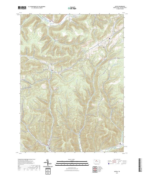 2023 Austin2023 Print · USGSPotter County's deep hollows and high ridges are shown here in recent detail, centered on the historic borough of Austin. Genealogists and historians can trace family sites at Odin Cem and Moores Run Cem or explore the rural settlements of Odin and Inez.
 - 2023 Map of Ayers Hill, 2023 Print
 2023 Ayers Hill2023 Print · USGSPotter County’s high plateau country is shown here in the modern era, where steep hollows and ridges define the rural landscape. Researchers can locate remote family burial sites like Old Knickerbocker Farm Cem and Ianson Cem or trace the winding course of Prouty Run.
End of results
Showing maps 1-19 of 19
Top cities near Homer Township
- Emporium historical maps
- Liberty Township historical maps
- Roulette Township historical maps
- Genesee Township historical maps
- Sweden Township historical maps
- Hebron Township historical maps
See more
Top neighborhoods of Homer Township
Frequently asked questions
- What are the different types of historical maps available for Homer Township?
- What is the oldest map of Homer Township?
- Where can I purchase historical maps of Homer Township for my home or office?
- Where can I download high-res historical maps of Homer Township?
- Are there historical topographic maps available for Homer Township?
- Is there historical aerial imagery available for Homer Township?
- Where are historical maps of Homer Township sourced from?