1930s Maps of Ice Mine, Sweden Township
Explore 2 historic maps of Ice Mine from the 1930s. These maps offer a rare glimpse into what life looked like during the 1930s — showing old roads, neighborhoods, homes, and landmarks that have changed or disappeared over time.
Whether you're researching your family's past, planning a metal detecting trip, or studying how Ice Mine's landscape evolved across the 1930s, these high-resolution maps are a powerful tool for exploring the history of this region.
- Focus on a specific era: All maps on this page are from the 1930s, giving you a focused view of this time period.
- See what’s changed: Compare century-old streets, trails, and buildings to today's modern landscape using overlays and satellite layers.
- Research with precision: Use these maps for genealogy, historical research, land use analysis, or educational projects.
- View, download, or print: Maps are fully viewable online in high resolution, and can be downloaded or printed for your own records.
Start exploring Ice Mine's history through authentic maps from the 1930s. This is your window into the past.
Ice Mine, Sweden Township maps
(2)- 1932 Map of Genesee, 1961 Print
 1932 Genesee1961 Print · USGSNorthern Pennsylvania’s high plateau is captured here in the early thirties, showing the transition from timber-hauling rail lines to mountain highways. Genealogists can locate family names at Andrews Settlement, the Sweden Hill Cem, or the Ice Mine.
 - 1937 Map of Genesee
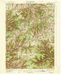 1937 Genesee1937 Print · USGSPotter County’s high plateau is captured in the 1930s when the headwaters of the Allegheny River and Genesee River met a complex network of mountain railroads. Genealogists can locate family landmarks like Sweden Hill Cem, the Ice Mine, and numerous district schools including Judd Sch.3 unique versions available
End of results
Showing maps 1-2 of 2
Top cities near Ice Mine
- Roulette Township historical maps
- Harrison Township historical maps
- Genesee Township historical maps
- Sweden Township historical maps
- Ulysses historical maps
- Hebron Township historical maps
See more
Frequently asked questions
- What are the different types of historical maps available for Ice Mine?
- What is the oldest map of Ice Mine?
- Where can I purchase historical maps of Ice Mine for my home or office?
- Where can I download high-res historical maps of Ice Mine?
- Are there historical topographic maps available for Ice Mine?
- Is there historical aerial imagery available for Ice Mine?
- Where are historical maps of Ice Mine sourced from?