1960s Maps of Jenner Township, Pennsylvania
Explore 5 historic maps of Jenner Township from the 1960s. These maps offer a rare glimpse into what life looked like during the 1960s — showing old roads, neighborhoods, homes, and landmarks that have changed or disappeared over time.
Whether you're researching your family's past, planning a metal detecting trip, or studying how Jenner Township's landscape evolved across the 1960s, these high-resolution maps are a powerful tool for exploring the history of this region.
- Focus on a specific era: All maps on this page are from the 1960s, giving you a focused view of this time period.
- See what’s changed: Compare century-old streets, trails, and buildings to today's modern landscape using overlays and satellite layers.
- Research with precision: Use these maps for genealogy, historical research, land use analysis, or educational projects.
- View, download, or print: Maps are fully viewable online in high resolution, and can be downloaded or printed for your own records.
Start exploring Jenner Township's history through authentic maps from the 1960s. This is your window into the past.
Jenner Township, PA maps
(5)- 1964 Map of Pittsburgh
 1964 Pittsburgh1964 Print · USGSWestern Pennsylvania in the late fifties and early sixties shows a landscape of powerful river industries and expanding highways. Genealogists and historians can trace the rail corridors of the Pennsylvania RR through industrial hubs like Johnstown, Altoona, and Nanty Glo.
 - 1964 Map of Rachelwood, 1966 Print
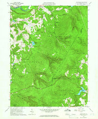 1964 Rachelwood1966 Print · USGSLaurel Ridge and the Conemaugh River define this Pennsylvania mountain landscape during the early sixties. Researchers can trace family sites and local landmarks like Legat Cem, the historic Baldwin Furnace, and Ross Mountain Park.3 unique versions available
 - 1967 Map of Ligonier, 1971 Print
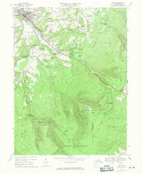 1967 Ligonier1971 Print · USGSWestmoreland County in the late sixties shows a transition from historical industrial sites to a prominent mountain recreation hub. Researchers can trace family roots at Laughlintown Cemetery or locate landmarks like California Furnace, the Marker School, and a Covered Bridge.4 unique versions available
 - 1967 Map of Somerset, 1971 Print
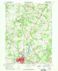 1967 Somerset1971 Print · USGSSomerset and its surrounding coal-and-rail townships are captured here in the late sixties as the modern turnpike era began to reshape the landscape. Genealogists and local historians can trace family-named sites like Weller Cem, rural centers such as Listie, and the grounds of the Somerset State Hospital.6 unique versions available
 - 1967 Map of Boswell, 1971 Print
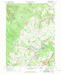 1967 Boswell1971 Print · USGSSomerset County’s coal country and rural settlements are captured in the late 1960s, showing the intersection of heavy industry and small-town life. Genealogists can trace family landmarks like Klines Mill, St Marys Ch, and the many cemeteries near Boswell.5 unique versions available
End of results
Showing maps 1-5 of 5
Top cities near Jenner Township
- Johnstown historical maps
- Somerset historical maps
- Franklin historical maps
- Westmont historical maps
- Windber historical maps
- Stonycreek Township historical maps
See more
Top neighborhoods of Jenner Township
- Laurel Mountain Village historical maps
- Maidadale historical maps
- Jenners historical maps
- Jenners Crossroads historical maps
- Pilltown historical maps
- Randolph historical maps
See more
Frequently asked questions
- What are the different types of historical maps available for Jenner Township?
- What is the oldest map of Jenner Township?
- Where can I purchase historical maps of Jenner Township for my home or office?
- Where can I download high-res historical maps of Jenner Township?
- Are there historical topographic maps available for Jenner Township?
- Is there historical aerial imagery available for Jenner Township?
- Where are historical maps of Jenner Township sourced from?