1940s Maps of West Auburn, Auburn Township
Explore 3 historic maps of West Auburn from the 1940s. These maps offer a rare glimpse into what life looked like during the 1940s — showing old roads, neighborhoods, homes, and landmarks that have changed or disappeared over time.
Whether you're researching your family's past, planning a metal detecting trip, or studying how West Auburn's landscape evolved across the 1940s, these high-resolution maps are a powerful tool for exploring the history of this region.
- Focus on a specific era: All maps on this page are from the 1940s, giving you a focused view of this time period.
- See what’s changed: Compare century-old streets, trails, and buildings to today's modern landscape using overlays and satellite layers.
- Research with precision: Use these maps for genealogy, historical research, land use analysis, or educational projects.
- View, download, or print: Maps are fully viewable online in high resolution, and can be downloaded or printed for your own records.
Start exploring West Auburn's history through authentic maps from the 1940s. This is your window into the past.
West Auburn, Auburn Township maps
(3)- 1945 Map of Meshoppen, 1952 Print
 1945 Meshoppen1952 Print · USGSNortheastern Pennsylvania hill country and the winding Susquehanna River are captured here in the years following the war. Researchers can trace the legacy of small farming and rail communities through landmarks like Skinners Eddy, Mehoopany Sta, and Golden Hill Sch.4 unique versions available
 - 1945 Map of Auburn Center, 1956 Print
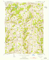 1945 Auburn Center1956 Print · USGSSusquehanna County farming communities are captured here in the mid-1940s, showing a landscape of small hamlets and family-named hills. Researchers can locate specific homesteads near Auburn Center, Boles Cem., and several rural churches like Shannon Hill Ch.6 unique versions available
 - 1947 Map of Auburn Center
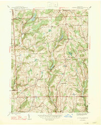 1947 Auburn Center1947 Print · USGSSusquehanna County in the late 1940s is a landscape of high ridges and rural crossroads communities. Genealogists and local historians can trace family locations near Boles Cem. or investigate old community centers like Retta, Rushboro, and South Auburn.2 unique versions available
End of results
Showing maps 1-3 of 3
Top cities near West Auburn
- Bridgewater Township historical maps
- Falls Township historical maps
- Tunkhannock historical maps
- Wysox Township historical maps
- Springville Township historical maps
- Silver Lake Township historical maps
See more
Frequently asked questions
- What are the different types of historical maps available for West Auburn?
- What is the oldest map of West Auburn?
- Where can I purchase historical maps of West Auburn for my home or office?
- Where can I download high-res historical maps of West Auburn?
- Are there historical topographic maps available for West Auburn?
- Is there historical aerial imagery available for West Auburn?
- Where are historical maps of West Auburn sourced from?