1940s Maps of Harford Township, Pennsylvania
Explore 7 historic maps of Harford Township from the 1940s. These maps offer a rare glimpse into what life looked like during the 1940s — showing old roads, neighborhoods, homes, and landmarks that have changed or disappeared over time.
Whether you're researching your family's past, planning a metal detecting trip, or studying how Harford Township's landscape evolved across the 1940s, these high-resolution maps are a powerful tool for exploring the history of this region.
- Focus on a specific era: All maps on this page are from the 1940s, giving you a focused view of this time period.
- See what’s changed: Compare century-old streets, trails, and buildings to today's modern landscape using overlays and satellite layers.
- Research with precision: Use these maps for genealogy, historical research, land use analysis, or educational projects.
- View, download, or print: Maps are fully viewable online in high resolution, and can be downloaded or printed for your own records.
Start exploring Harford Township's history through authentic maps from the 1940s. This is your window into the past.
Harford Township, PA maps
(7)- 1943 Map of Montrose, 1957 Print
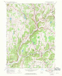
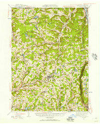 1943 Montrose1957 Print · USGSSusquehanna County at the height of the mid-century railroad era shows a landscape of upland farms and valley rail junctions. Researchers can locate long-standing family landmarks and rural hubs like South Montrose, the Lehigh Valley line, and Prospect Hill Cem.3 unique versions available
 - 1945 Map of Montrose
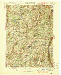 1945 Montrose1945 Print · USGSSusquehanna County is shown in the mid-1940s as a landscape of rural schoolhouses and established rail corridors. Genealogists and historians can locate family landmarks such as Prospect Hill Cem, tracing the paths between Montrose and the mills at Snows Mill.2 unique versions available
 - 1946 Map of Tunkhannock, 1952 Print
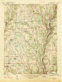
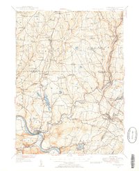 1946 Tunkhannock1952 Print · USGSThe northern Susquehanna River valley and the Wyoming County highlands are captured here in the mid-1940s. Genealogists and historians can trace the rail-connected settlements of Nicholson and Springville or locate family landmarks like Bunnell Cem and Castle Sch.3 unique versions available
 - 1946 Map of Hop Bottom, 1971 Print
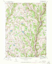 1946 Hop Bottom1971 Print · USGSSusquehanna County in the mid-twentieth century shows a landscape of steep creek valleys and high ridge farming. Genealogists can trace family names at St Patricks Cem, locate the Squier Hill Sch, and follow the Erie Lackawanna RR corridor.
 - 1946 Map of Lenoxville, 1971 Print
 1946 Lenoxville1971 Print · USGSSusquehanna County’s rural valleys and ridges are captured here in the mid-forties, showing the transition of small farming communities. Researchers can trace the locations of local landmarks like West Lenox Ch, Wright Sch, and the riverside settlement of Glenwood.3 unique versions available
 - 1947 Map of Hopbottom
 1947 Hopbottom1947 Print · USGSSusquehanna and Wyoming counties appear here in the late 1940s as a landscape of deep rail valleys and upland farms. Family historians can locate several rural burial grounds like Squier Cem and Deckertown Cem, or trace the Delaware Lackawanna and Western through Hopbottom.
 - 1949 Map of Lenoxville
 1949 Lenoxville1949 Print · USGSSusquehanna County in the late 1940s reveals a network of tight-knit valley settlements and upland farms connected by winding creek-side roads. Researchers can locate family landmarks like South Gibson Cem, the Mount View Airport, and historic rural schoolhouses including Wilson Sch and Green Grove Sch.
End of results
Showing maps 1-7 of 7
Top cities near Harford Township
- Carbondale historical maps
- Scott Township historical maps
- Bridgewater Township historical maps
- Clifford Township historical maps
- Lenox Township historical maps
- Springville Township historical maps
See more
Top neighborhoods of Harford Township
Frequently asked questions
- What are the different types of historical maps available for Harford Township?
- What is the oldest map of Harford Township?
- Where can I purchase historical maps of Harford Township for my home or office?
- Where can I download high-res historical maps of Harford Township?
- Are there historical topographic maps available for Harford Township?
- Is there historical aerial imagery available for Harford Township?
- Where are historical maps of Harford Township sourced from?