1960s Maps of Union County, Pennsylvania
Explore 20 historic maps of Union County from the 1960s. These maps offer a rare glimpse into what life looked like during the 1960s — showing old roads, neighborhoods, homes, and landmarks that have changed or disappeared over time.
Whether you're researching your family's past, planning a metal detecting trip, or studying how Union County's landscape evolved across the 1960s, these high-resolution maps are a powerful tool for exploring the history of this region.
- Focus on a specific era: All maps on this page are from the 1960s, giving you a focused view of this time period.
- See what’s changed: Compare century-old streets, trails, and buildings to today's modern landscape using overlays and satellite layers.
- Research with precision: Use these maps for genealogy, historical research, land use analysis, or educational projects.
- View, download, or print: Maps are fully viewable online in high resolution, and can be downloaded or printed for your own records.
Start exploring Union County's history through authentic maps from the 1960s. This is your window into the past.
Union County, PA maps
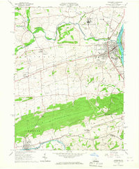
(20)- 1960 Map of Williamsport
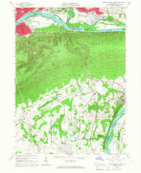
 1960 Williamsport1960 Print · USGSNorth-central Pennsylvania in the mid-twentieth century was a vital corridor of rail and river industry stretching from the New York line to the coal regions. Genealogists can trace the rail networks of the Pennsylvania RR and Lehigh Valley RR connecting towns like Williamsport, Towanda, and Lock Haven.
 - 1961 Map of Harrisburg
 1961 Harrisburg1961 Print · USGSCentral Pennsylvania is shown at a mid-century peak of industrial and military activity, from the Susquehanna water gaps to the fertile Dutch Country. Genealogists and historians can trace the rail corridors of the Pennsylvania RR and find landmarks like Carlisle Barracks or the Anthracite Coal Fields.2 unique versions available
 - 1962 Map of Williamsport, 1966 Print
 1962 Williamsport1966 Print · USGSNorth-central Pennsylvania was a landscape of industrial river hubs and vast state woodlands in the early sixties. Researchers can trace the path of the Pennsylvania Railroad through Williamsport and explore the remote reaches of Bucktail State Park.5 unique versions available
 - 1964 Map of Harrisburg
 1964 Harrisburg1964 Print · USGSCentral Pennsylvania in the mid-fifties reveals a landscape shaped by ridge-and-valley geology and critical Cold War infrastructure. Researchers can trace the massive Indiantown Gap Military Reservation or the rail corridors of the Pennsylvania RR and Reading RR.
 - 1965 Map of Williamsport
 1965 Williamsport1965 Print · USGSNorth-central Pennsylvania in the mid-1960s is defined by the industrial river towns and vast timberlands of the Allegheny Plateau. Researchers can trace historic rail lines like the Erie Lackawanna and Reading as they thread through Williamsport, Lock Haven, and Jersey Shore.
 - 1965 Map of Mifflinburg, 1966 Print
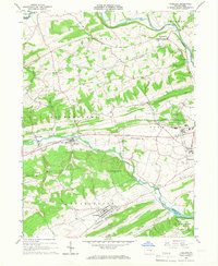
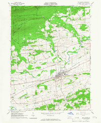 1965 Mifflinburg1966 Print · USGSUnion County during the mid-sixties shows a landscape of productive valleys and forested ridges centered on the town of Mifflinburg. Researchers can trace the Pennsylvania rail corridor and locate rural landmarks like St Peters Ch and the hamlet of Forest Hill.2 unique versions available
 - 1965 Map of Beavertown, 1966 Print
 1965 Beavertown1966 Print · USGSSnyder and Union Counties come into focus during the mid-sixties, showcasing a landscape of ridge-and-valley farming and forest. Researchers can locate family landmarks like Cedar Hill Cem, the Covered Bridge at Middle Creek, and the old Messiah Ch.3 unique versions available
 - 1965 Map of Milton, 1966 Print
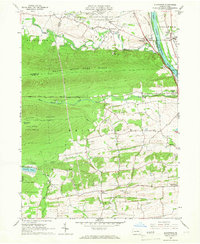
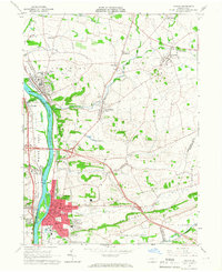 1965 Milton1966 Print · USGSThe Susquehanna River valley and its industrial hubs are seen here in the mid-sixties, capturing the rail-and-river network of Northumberland and Union counties. Researchers can locate many family landmarks, including Milton Cemetery, the Milton Airport, and the Warrior Run High School.4 unique versions available
 - 1965 Map of Middleburg, 1966 Print
 1965 Middleburg1966 Print · USGSSnyder County in the mid-sixties reveals a landscape of ridge-and-valley industry and quiet borough life centered on Middleburg. Genealogists and historians can trace family locations through numerous landmarks like Glendale Cem, the rural settlement of Coon Hunter, and the Limestone Quarry near the western hills.3 unique versions available
 - 1965 Map of Carroll, 1967 Print
 1965 Carroll1967 Print · USGSCentral Pennsylvania's ridge-and-valley terrain is captured here in the mid-1960s, showing the isolated communities of Carroll and Eastville. Researchers can locate family sites at the Sugar Valley Ch Cem or trace the old paths through McMurrin Gap and past the Mt Union Ch.4 unique versions available
 - 1965 Map of Montoursville South, 1967 Print
 1965 Montoursville South1967 Print · USGSLycoming and Union counties are shown in the mid-1960s, documenting the corridor from Williamsport to the prison camp at Allenwood. Trace genealogy and local landmarks from Mt Zion Ch and Washington Cem to the early Reading rail lines.4 unique versions available
 - 1965 Map of Williamsport SE, 1967 Print
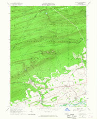
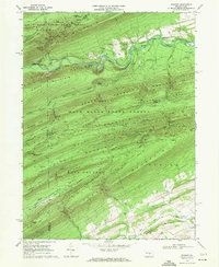
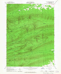 1965 Williamsport SE1967 Print · USGSThe ridge-and-valley heart of Union County is captured here in the mid-1960s, showing a vast expanse of state-managed forest land. Local historians can trace the paths of White Deer Creek and locate landmarks like McKean Spring and Spruce Run Reservoir.3 unique versions available
 - 1965 Map of Freeburg, 1967 Print
 1965 Freeburg1967 Print · USGSSnyder County's mid-century landscape is defined here by the parallel ridges surrounding Middle Creek during a period of steady institutional growth. Genealogists and historians can trace the foundations of Freeburg, locate the Hermans Sch (Historic), and explore the grounds of Susquehanna University.2 unique versions available
 - 1965 Map of Northumberland, 1967 Print
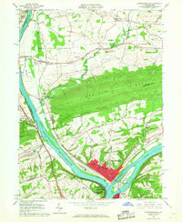 1965 Northumberland1967 Print · USGSThe Susquehanna River forks meet at Northumberland and Sunbury in the mid-1960s, capturing a landscape of vital riverfront industry and transit. Researchers can trace the rail lines of the Erie-Lackawanna and Reading or locate local landmarks like the Sodom Sch (Historic) and Packers Island.4 unique versions available
 - 1965 Map of Lewisburg, 1967 Print
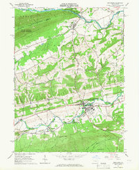
 1965 Lewisburg1967 Print · USGSUnion County during the mid-sixties reveals a landscape of academic tradition, rural hamlets, and heavy institutional presence. Researchers can trace the layout of Bucknell University or find long-standing rural landmarks like Emmanuel Ch and the Northeast Federal Penitentiary.2 unique versions available
 - 1965 Map of Hartleton, 1967 Print
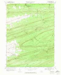
 1965 Hartleton1967 Print · USGSThe heart of Union County in the mid-sixties reveals a landscape where state forests and small valley settlements meet. Researchers can find precise locations for the Laurelton State Village, the Western Area Sch, and a Covered Bridge crossing Penns Creek.2 unique versions available
 - 1965 Map of Allenwood, 1967 Print
 1965 Allenwood1967 Print · USGSThe Susquehanna River valley and the slopes of the Bald Eagle State Forest are captured here in the mid-sixties. Genealogists and local historians can trace the foundations of Kelly Crossroads, find the Washington Cem, and locate landmarks like the Allenwood Prison Camp.3 unique versions available
 - 1966 Map of Williamsport
 1966 Williamsport1966 Print · USGSThe Susquehanna Valley was a hub of transit and industry in the mid-seventies, where the river's West Branch connected major college towns and timberlands. Researchers can trace historical rail lines like the Reading or locate regional landmarks from Jersey Shore to Ricketts Glen State Park.
 - 1968 Map of Woodward, 1971 Print
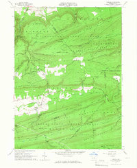
 1968 Woodward1971 Print · USGSPennsylvania’s central ridges are captured here in the late sixties, showing a landscape of state forest lands and narrow valley gaps. Researchers can locate small communities like Woodward and Livonia, or trace old paths and natural features such as Horse Path Spring and Wolfs Store Gap.3 unique versions available
 - 1968 Map of Weikert, 1971 Print
 1968 Weikert1971 Print · USGSSnyder and Union counties are defined by steep forested ridges and the winding path of Penns Creek in this late-sixties topographic study. Trace the local history of timber and recreation through sites like Weikert, Hironimus Ch, and Nik-O-Mahs Camp.2 unique versions available
End of results
Showing maps 1-20 of 20
Top cities of Union County
- Lewisburg historical maps
- White Deer Township historical maps
- Mifflinburg historical maps
- Hartleton historical maps
Frequently asked questions
- What are the different types of historical maps available for Union County?
- What is the oldest map of Union County?
- Where can I purchase historical maps of Union County for my home or office?
- Where can I download high-res historical maps of Union County?
- Are there historical topographic maps available for Union County?
- Is there historical aerial imagery available for Union County?
- Where are historical maps of Union County sourced from?