1960s Maps of Limestone Township, Pennsylvania
Explore 6 historic maps of Limestone Township from the 1960s. These maps offer a rare glimpse into what life looked like during the 1960s — showing old roads, neighborhoods, homes, and landmarks that have changed or disappeared over time.
Whether you're researching your family's past, planning a metal detecting trip, or studying how Limestone Township's landscape evolved across the 1960s, these high-resolution maps are a powerful tool for exploring the history of this region.
- Focus on a specific era: All maps on this page are from the 1960s, giving you a focused view of this time period.
- See what’s changed: Compare century-old streets, trails, and buildings to today's modern landscape using overlays and satellite layers.
- Research with precision: Use these maps for genealogy, historical research, land use analysis, or educational projects.
- View, download, or print: Maps are fully viewable online in high resolution, and can be downloaded or printed for your own records.
Start exploring Limestone Township's history through authentic maps from the 1960s. This is your window into the past.
Limestone Township, PA maps
(6)- 1961 Map of Harrisburg
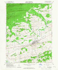
 1961 Harrisburg1961 Print · USGSCentral Pennsylvania is shown at a mid-century peak of industrial and military activity, from the Susquehanna water gaps to the fertile Dutch Country. Genealogists and historians can trace the rail corridors of the Pennsylvania RR and find landmarks like Carlisle Barracks or the Anthracite Coal Fields.2 unique versions available
 - 1964 Map of Harrisburg
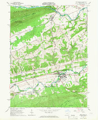
 1964 Harrisburg1964 Print · USGSCentral Pennsylvania in the mid-fifties reveals a landscape shaped by ridge-and-valley geology and critical Cold War infrastructure. Researchers can trace the massive Indiantown Gap Military Reservation or the rail corridors of the Pennsylvania RR and Reading RR.
 - 1965 Map of Mifflinburg, 1966 Print
 1965 Mifflinburg1966 Print · USGSUnion County during the mid-sixties shows a landscape of productive valleys and forested ridges centered on the town of Mifflinburg. Researchers can trace the Pennsylvania rail corridor and locate rural landmarks like St Peters Ch and the hamlet of Forest Hill.2 unique versions available
 - 1965 Map of Middleburg, 1966 Print
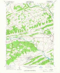
 1965 Middleburg1966 Print · USGSSnyder County in the mid-sixties reveals a landscape of ridge-and-valley industry and quiet borough life centered on Middleburg. Genealogists and historians can trace family locations through numerous landmarks like Glendale Cem, the rural settlement of Coon Hunter, and the Limestone Quarry near the western hills.3 unique versions available
 - 1965 Map of Freeburg, 1967 Print
 1965 Freeburg1967 Print · USGSSnyder County's mid-century landscape is defined here by the parallel ridges surrounding Middle Creek during a period of steady institutional growth. Genealogists and historians can trace the foundations of Freeburg, locate the Hermans Sch (Historic), and explore the grounds of Susquehanna University.2 unique versions available
 - 1965 Map of Lewisburg, 1967 Print
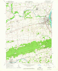 1965 Lewisburg1967 Print · USGSUnion County during the mid-sixties reveals a landscape of academic tradition, rural hamlets, and heavy institutional presence. Researchers can trace the layout of Bucknell University or find long-standing rural landmarks like Emmanuel Ch and the Northeast Federal Penitentiary.2 unique versions available
End of results
Showing maps 1-6 of 6
Top cities near Limestone Township
- Sunbury historical maps
- Lewisburg historical maps
- Selinsgrove historical maps
- White Deer Township historical maps
- Mifflinburg historical maps
- Shamokin Dam historical maps
See more
Top neighborhoods of Limestone Township
Frequently asked questions
- What are the different types of historical maps available for Limestone Township?
- What is the oldest map of Limestone Township?
- Where can I purchase historical maps of Limestone Township for my home or office?
- Where can I download high-res historical maps of Limestone Township?
- Are there historical topographic maps available for Limestone Township?
- Is there historical aerial imagery available for Limestone Township?
- Where are historical maps of Limestone Township sourced from?