Old Maps of Bentleyville, Pennsylvania for Genealogy
Trace your family roots with 44 historic maps of Bentleyville. These high-res maps reveal old neighborhoods, homesites, landmarks, and streets — helping you uncover where your ancestors lived and how the area evolved over time.
- Explore historic neighborhoods: Identify where your relatives may have lived in the 1800s or 1900s.
- Compare maps over time: Trace the changes in streets, buildings, and landmarks for multi-generational research.
- Perfect for genealogy & ancestry research: Used by family historians and researchers to map out lineage and migration.
These maps are an incredible resource for exploring your personal connection to Bentleyville's past.
Bentleyville, PA maps
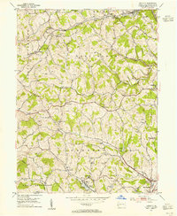
(44)- 1901 Map of Amity, 1956 Print
 1901 Amity1956 Print · USGSWashington County at the turn of the century shows a landscape transitioning between historic pikes and the burgeoning rail era. Researchers can trace ancestral property near Tenmile Creek or follow the route of the National Pike through Laboratory and Zediker.
 - 1902 Map of Brownsville
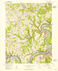
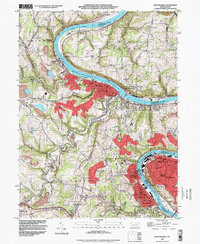
 1902 Brownsville1902 Print · USGSThe Monongahela Valley was a powerhouse of Pennsylvania industry at the start of the twentieth century, defined by its coal mines and river-front rail lines. Researchers can trace the heritage of the National Pike and locate vanished works at Vesta Mine or Coal Bluff.
 - 1904 Map of Amity
 1904 Amity1904 Print · USGSWashington County at the start of the twentieth century was a bustling nexus of rail and road, centered on the growing city of WASHINGTON. Researchers can trace early property lines and rail stops like Meadowlands, Laboratory, and the Pittsburg and Washington Turnpike.6 unique versions available
 - 1906 Map of Brownsville
 1906 Brownsville1906 Print · USGSSouthwestern Pennsylvania’s river valleys were centers of industrial expansion when this survey was conducted. Genealogists can locate family homes and landmarks in riverfront towns like Monessen and Charleroi, or trace rural roots near Salem Church and Ginger Hill.4 unique versions available
 - 1931 Map of Brownsville, 1954 Print
 1931 Brownsville1954 Print · USGSThe industrial Monongahela and Youghiogheny river valleys are captured here in the early thirties, showcasing a landscape of coal mines and river locks. Genealogists can trace family homes near Vesta Mine, Sutersville, and rural landmarks like Salem Church.
 - 1933 Map of Brownsville
 1933 Brownsville1933 Print · USGSWestern Pennsylvania’s industrial heartland thrives along the river bends in the early thirties, where coal and rail define the landscape. Trace the expansion of river towns like Charleroi and Monessen, locate the Vesta Mine, or find rural landmarks like Mt Union Sch.2 unique versions available
 - 1940 Map of Brownsville
 1940 Brownsville1940 Print · USGSThe Monongahela and Youghiogheny river valleys were the industrial heart of Pennsylvania during this era of coal and steel. Genealogists and historians can trace the exact locations of Vesta Mine, Salem Church, and historic rural schools like Central Sch.
 - 1951 Map of Canton
 1951 Canton1951 Print · USGSThe industrial heartland of Ohio and Pennsylvania reached its mid-century peak during this era of heavy rail and river transit. Genealogists and historians can trace the development of steel towns like Aliquippa and Weirton alongside the Ohio River and major lines of the Pennsylvania RR.
 - 1953 Map of Pittsburgh
 1953 Pittsburgh1953 Print · USGSWestern Pennsylvania's industrial landscape at the start of the fifties shows the steel and rail corridors between Pittsburgh and Altoona. Trace family roots in river towns like Tarentum or follow the Pennsylvania Turnpike across Laurel Hill.
 - 1953 Map of Canton
 1953 Canton1953 Print · USGSThe industrial heartland of Ohio and Pennsylvania is captured at its mid-century peak in this detailed regional survey. Genealogists and historians can trace the vast rail networks of the Pennsylvania RR and find local landmarks like Nimisila Reservoir and Tappan Reservoir.
 - 1953 Map of Hackett, 1955 Print
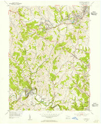
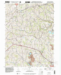
 1953 Hackett1955 Print · USGSWashington County coal and gas country is captured here in the mid-fifties as the local economy revolved around mining and the rail. Genealogists and historians can trace the foundations of Bentleyville and find rural landmarks like Munntown Cem and Edwards Chapel.6 unique versions available
 - 1954 Map of Pittsburgh
 1954 Pittsburgh1954 Print · USGSWestern Pennsylvania in the early fifties remains a powerhouse of heavy industry and vital transit corridors. Genealogists and historians can trace the rail-and-river network connecting Pittsburgh, Johnstown, and Altoona via the Pennsylvania RR and the Lincoln Highway.2 unique versions available
 - 1954 Map of California, 1955 Print
 1954 California1955 Print · USGSThe Monongahela river valley and the historic coal country of Washington County are shown here in the mid-fifties. Researchers can trace the industrial footprint of Vesta No 6 Mine, locate the campus of State Teachers College, or find family landmarks like Maple Creek Cem.3 unique versions available
 - 1954 Map of Ellsworth, 1955 Print
 1954 Ellsworth1955 Print · USGSWashington County at the height of its industrial era reveals a landscape of coal patches, rail spurs, and historic crossroads. Genealogists and historians can trace family roots through the numerous rural schools and cemeteries, from Old Zollarsville to the St Clements Cem.5 unique versions available
 - 1954 Map of Monongahela, 1955 Print
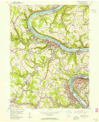 1954 Monongahela1955 Print · USGSIndustrial life along the river valley is captured here in the mid-fifties, showing the deep integration of coal mining and rail transport. Researchers can locate family landmarks from the Black Diamond Mine to the Mentor School and Ohav Sholom Cem.4 unique versions available
 - 1957 Map of Canton, 1971 Print
 1957 Canton1971 Print · USGSThe industrial heartland of eastern Ohio and western Pennsylvania comes alive in this mid-century survey of the Ohio River Valley. Trace the heritage of rail and river commerce through Pittsburgh, the massive steel towns along the Ohio River, and major junctions on the Pennsylvania RR.3 unique versions available
 - 1958 Map of Pittsburgh
 1958 Pittsburgh1958 Print · USGSWestern Pennsylvania in the late fifties shows an industrial heartland defined by the confluence of the Allegheny River and Monongahela River. Researchers can trace the sprawling rail networks of the Pennsylvania RR and find established towns like Butler, Latrobe, and Windber.5 unique versions available
 - 1959 Map of Pittsburgh
 1959 Pittsburgh1959 Print · USGSWestern Pennsylvania in the late fifties is captured here at the height of its industrial era. Genealogists and historians can trace the riverfront growth of Pittsburgh, the rail works at Altoona, and the mountain gaps of Laurel Hill.
 - 1962 Map of Canton
 1962 Canton1962 Print · USGSThe industrial heartland of Eastern Ohio and Western Pennsylvania thrives in the early sixties as steel mills and rail lines dominate the river valleys. Genealogists and historians can trace local landmarks like McKinley National Memorial, Malone College, and industrial sites such as Republic Steel Corp.2 unique versions available
 - 1964 Map of Pittsburgh
 1964 Pittsburgh1964 Print · USGSWestern Pennsylvania in the late fifties and early sixties shows a landscape of powerful river industries and expanding highways. Genealogists and historians can trace the rail corridors of the Pennsylvania RR through industrial hubs like Johnstown, Altoona, and Nanty Glo.
 - 1986 Map of Pittsburgh West
 1986 Pittsburgh West1986 Print · USGSThe Tri-State region's coal and rail corridors are captured in the mid-eighties as industry and aviation expanded. Trace the legacy of extraction at Nelms Mine No 1, locate Short Creek PO, or follow the Chessie System tracks along the Ohio River.3 unique versions available
 - 1986 Map of Pittsburgh East
 1986 Pittsburgh East1986 Print · USGSWestern Pennsylvania in the mid-eighties shows a landscape defined by industrial rivers and rising mountain ridges. Trace the dense rail networks of CONRAIL and the Pittsburgh and Lake Erie RR connecting historic centers like Monessen, Jeannette, and Connellsville.3 unique versions available
 - 1993 Map of Monongahela, 1999 Print
 1993 Monongahela1999 Print · USGSThe industrial Monongahela Valley is captured in the early nineties, showing a landscape shaped by river commerce and mining. Researchers can trace family roots at Taylor Cem or locate historic landmarks like Shire Oaks and Hazel Kirk.
 - 1993 Map of Hackett, 1999 Print
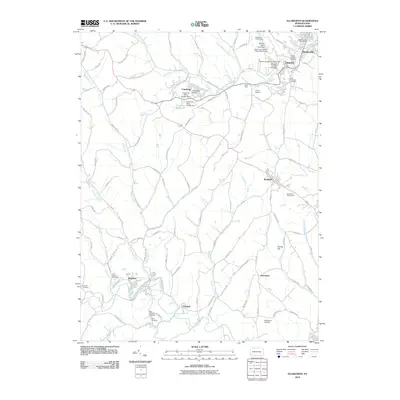
 1993 Hackett1999 Print · USGSThe hill country of Washington County appears in the late twentieth century as a landscape of deep-rooted rural townships and legacy coal mining. Researchers can trace family sites at Munnstown Cem, locate the Thomas Tunnel, or explore settlements like Venetia and Bentleyville.
 - 2010 Map of Ellsworth, 2010 Print
 2010 Ellsworth2010 Print · USGSCovers Bentleyville, including Ellsworth, Deemston, and other nearby areas
Showing maps 1-25 of 44
Top cities near Bentleyville
- Bethel Park historical maps
- McKeesport historical maps
- Baldwin historical maps
- Upper St. Clair historical maps
- Washington historical maps
- Cecil Township historical maps
See more
Top neighborhoods of Bentleyville
Frequently asked questions
- What are the different types of historical maps available for Bentleyville?
- What is the oldest map of Bentleyville?
- Where can I purchase historical maps of Bentleyville for my home or office?
- Where can I download high-res historical maps of Bentleyville?
- Are there historical topographic maps available for Bentleyville?
- Is there historical aerial imagery available for Bentleyville?
- Where are historical maps of Bentleyville sourced from?