1990s Maps of Donegal Township, Pennsylvania
Explore 3 historic maps of Donegal Township from the 1990s. These maps offer a rare glimpse into what life looked like during the 1990s — showing old roads, neighborhoods, homes, and landmarks that have changed or disappeared over time.
Whether you're researching your family's past, planning a metal detecting trip, or studying how Donegal Township's landscape evolved across the 1990s, these high-resolution maps are a powerful tool for exploring the history of this region.
- Focus on a specific era: All maps on this page are from the 1990s, giving you a focused view of this time period.
- See what’s changed: Compare century-old streets, trails, and buildings to today's modern landscape using overlays and satellite layers.
- Research with precision: Use these maps for genealogy, historical research, land use analysis, or educational projects.
- View, download, or print: Maps are fully viewable online in high resolution, and can be downloaded or printed for your own records.
Start exploring Donegal Township's history through authentic maps from the 1990s. This is your window into the past.
Donegal Township, PA maps
(3)- 1997 Map of Bethany, 2000 Print
 1997 Bethany2000 Print · USGSThe West Virginia panhandle near the Pennsylvania line is home to storied campuses and deep-seated rural traditions. Researchers can find prominent landmarks like Bethany College, the historic Alexander Campbell Mansion, and the Lower Buffalo Cem.
 - 1997 Map of Valley Grove, 2000 Print
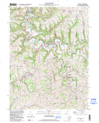
 1997 Valley Grove2000 Print · USGSThe West Virginia and Pennsylvania borderlands come alive in the late nineties, centered on the historic National Road corridor. Trace family roots at West Alexander and Triadelphia, or locate the old County Home and Sanatorium.
 - 1998 Map of Claysville, 1999 Print
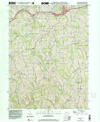 1998 Claysville1999 Print · USGSSouthwestern Pennsylvania’s rural heritage is preserved here in the late nineties, showcasing the ridge-and-valley landscape of Washington County. Researchers can trace the National Road and locate sites like Good Intent, St James Cem, and the East West Finley Sch.
End of results
Showing maps 1-3 of 3
Top cities near Donegal Township
- Wheeling historical maps
- Steubenville historical maps
- Washington historical maps
- Cecil Township historical maps
- South Strabane Township historical maps
- Mingo Junction historical maps
See more
Top neighborhoods of Donegal Township
- Budaville historical maps
- Coon Island historical maps
- Donley historical maps
- McMillan historical maps
- West Alexander historical maps
Frequently asked questions
- What are the different types of historical maps available for Donegal Township?
- What is the oldest map of Donegal Township?
- Where can I purchase historical maps of Donegal Township for my home or office?
- Where can I download high-res historical maps of Donegal Township?
- Are there historical topographic maps available for Donegal Township?
- Is there historical aerial imagery available for Donegal Township?
- Where are historical maps of Donegal Township sourced from?