1900s (20th Century) Maps of Wayne County, Pennsylvania
Explore 89 historic maps of Wayne County from the 1900s (20th Century). These maps offer a rare glimpse into what life looked like during the 1900s — showing old roads, neighborhoods, homes, and landmarks that have changed or disappeared over time.
Whether you're researching your family's past, planning a metal detecting trip, or studying how Wayne County's landscape evolved across the 1900s, these high-resolution maps are a powerful tool for exploring the history of this region.
- Focus on a specific era: All maps on this page are from the 1900s, giving you a focused view of this time period.
- See what’s changed: Compare century-old streets, trails, and buildings to today's modern landscape using overlays and satellite layers.
- Research with precision: Use these maps for genealogy, historical research, land use analysis, or educational projects.
- View, download, or print: Maps are fully viewable online in high resolution, and can be downloaded or printed for your own records.
Start exploring Wayne County's history through authentic maps from the 1900s. This is your window into the past.
Wayne County, PA maps
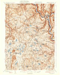
(89)- 1919 Map of Pocono
 1919 Pocono1919 Print · USGSMonroe County was a critical military and rail corridor at the close of the Great War. Researchers can trace the massive Tobyhanna Military Reservation and the early rail-centered footprints of Mount Pocono, Tannerville, and Cresco.
 - 1920 Map of Long Eddy
 1920 Long Eddy1920 Print · USGSThe Delaware River borderlands come alive in the 1920s as a hub of rail activity and riverfront commerce. Genealogists can locate family names near landmarks like Peckville P O, Equinunk, and rural schoolhouses like the South Branch School.3 unique versions available
 - 1920 Map of Damascus, 1956 Print
 1920 Damascus1956 Print · USGSThe Upper Delaware River valley at the start of the 1920s shows a landscape of river-fronting hamlets and upland dairy farms. Genealogists can locate numerous rural schoolhouses and churches, such as Kester School, Smith Hill Church, and the Oil Pumping Station at Cochecton.2 unique versions available
 - 1921 Map of Long Eddy
 1921 Long Eddy1921 Print · USGSThe Delaware River borderlands are captured here in the early twenties, showing a network of small upland communities and river crossings. Genealogists can trace family footprints through numerous rural schoolhouses and landmarks like Read Cemetery, Abrahamsville, and the Ferry.
 - 1921 Map of Pocono, 1962 Print
 1921 Pocono1962 Print · USGSThe Pocono Mountains at the start of the 1920s reveal a landscape of military training grounds, remote mountain schools, and early summer resorts. Trace the rail lines of the Wilkes-Barre and Eastern RR or locate rural landmarks like Cherry Lane Church and Beaver Brook School.
 - 1922 Map of Stoddartsville, 1958 Print
 1922 Stoddartsville1958 Print · USGSThe Pennsylvania Poconos at the turn of the century show a landscape of high timber ridges and early mountain resorts. Genealogists and hikers can trace the original paths to Stoddartsville, identify the old Fayette School, or follow the Wilkes-Barre and Eastern rail line.2 unique versions available
 - 1923 Map of Damascus
 1923 Damascus1923 Print · USGSThe Delaware River valley thrived as a corridor for rail and industry in the early twenties. Genealogists and historians can trace family-named landmarks like Stanton Corner or locate vanished infrastructure like the Oil Pumping Station and Nobody Station School.5 unique versions available
 - 1923 Map of Long Eddy
 1923 Long Eddy1923 Print · USGSThe Delaware River valley thrived in the 1920s as a rail and timber hub between New York and Pennsylvania. Genealogists can trace family roots through the many rural schoolhouses and riverside settlements like Lordville, Equinunk, and Fishs Eddy.5 unique versions available
 - 1923 Map of Pocono
 1923 Pocono1923 Print · USGSMonroe County was evolving into a mountain retreat in the early twenties, connected by the Delaware Lackawanna and Western RR. Researchers can trace early resort life at Lake Naomi, find rural schools like Butz School, and locate the expansive Artillery Reservation.5 unique versions available
 - 1924 Map of Starrucca
 1924 Starrucca1924 Print · USGSThe river-and-rail economy of the Delaware valley is captured here in the mid-1920s during a period of industrial activity. Researchers can trace the junctions of the Erie RR and locate local landmarks like Cadosia Factories and Stockport Sta.
 - 1924 Map of Stoddartsville
 1924 Stoddartsville1924 Print · USGSUpper Carbon and Monroe counties are shown in the early twenties as a landscape of timbered hills and headwater streams. Genealogists can locate old rural landmarks like Bradys Switch, the Leonardsville settlement, and the Locust Ridge School.5 unique versions available
 - 1926 Map of Starrucca
 1926 Starrucca1926 Print · USGSThe river-and-rail corridor at the New York and Pennsylvania border comes alive in the mid-1920s, showing the vital confluence at Hancock. Genealogists and rail historians can trace the paths of the Erie R R, identifying old transit points like Stockport Sta and Sands Switch.
 - 1928 Map of Ariel, 1953 Print
 1928 Ariel1953 Print · USGSWayne County was undergoing a significant transformation in the late twenties as the waters of Lake Wallenpaupack rose. Genealogists and historians can trace local family roots through sites like Haags Mill, German Valley Sch, and the Erie RR corridor.4 unique versions available
 - 1930 Map of Starrucca
 1930 Starrucca1930 Print · USGSUpper Wayne County was a major transportation and recreation hub in the 1930s, defined by the Delaware River rail corridors and numerous upland lakes. Genealogists can trace family roots through localized sites like the South Preston Grange Hall and schools like Fairmont Sch.3 unique versions available
 - 1932 Map of Ariel
 1932 Ariel1932 Print · USGSWayne and Pike counties are seen here in the early 1930s as the regional landscape adjusted to the presence of Lake Wallenpaupack. Trace family roots at Ammerman Sch or follow the Erie RR past Gravity and Lake Ariel.3 unique versions available
 - 1933 Map of Starrucca
 1933 Starrucca1933 Print · USGSUpper Wayne County was a landscape of rail-connected dairy farms and summer camps in the years between the wars. Genealogists can locate family-named rural schools and depots from Stephens Switch and Stockport Sta to Hines Corners.3 unique versions available
 - 1935 Map of Hawley, 1955 Print
 1935 Hawley1955 Print · USGSThe Pocono Mountains and the massive shoreline of Lake Wallenpaupack dominate this mid-century survey of northeastern Pennsylvania. Local historians can trace the Erie rail line through Hawley and Rowland or locate the High Knob Fire Tower and rural Blooming Grove School.2 unique versions available
 - 1938 Map of Hawley
 1938 Hawley1938 Print · USGSThe Pocono Mountains and the southern reaches of the Lackawaxen River appear here in the late thirties. Genealogists and local historians can trace the rural communities of Blooming Grove and Greeley or locate the Paupack Ch and numerous family-named swamps.3 unique versions available
 - 1943 Map of Scranton
 1943 Scranton1943 Print · USGSNortheastern Pennsylvania’s coal and rail corridor comes to life in the 1940s, showcasing the dense urban industrial centers of the Wyoming Valley. Genealogists can locate family landmarks like the Fayette School and Locust Ridge School or trace the early paths of the DL & W and Erie railroads.
 - 1943 Map of Stoddartsville
 1943 Stoddartsville1943 Print · USGSThe Pocono Plateau at the height of the Second World War shows a landscape defined by river valleys and developing recreation preserves. Genealogists and local historians can trace rural schoolhouses and small settlements like Stoddartsville, Albrightsville, and the Fishery Sch.
 - 1943 Map of Honesdale
 1943 Honesdale1943 Print · USGSThe northern Poconos and the Upper Delaware River valley appear here during the early war years, showing a network of mountain hamlets and riverfront rail towns. Genealogists can trace family roots through numerous remote institutions like Kingsbury Hill Church, Peakville P O, and the Hiawatha School.
 - 1943 Map of Pocono
 1943 Pocono1943 Print · USGSMonroe County was a well-established retreat and transportation hub in the early 1940s, centered around the Delaware Lackawanna and Western railroad. Researchers can trace old mountain roads and family-named landmarks like Camelback Mountain, Naomi Pines Sch, and the Mount Pocono Airport.
 - 1944 Map of Long Eddy
 1944 Long Eddy1944 Print · USGSThe Delaware River valley straddles the state line during the mid-forties, showing a landscape of isolated hill farms and riverside rail towns. Researchers can locate numerous vanished country schools such as Priceville Sch and Cooley Sch or trace the path of the Erie RR.
 - 1944 Map of Damascus
 1944 Damascus1944 Print · USGSUpper Delaware River communities in Wayne and Pike Counties appear here during the mid-forties, caught between the river's bends and the rising hills. Researchers can locate numerous rural schoolhouses and industrial sites, from the Oil Pumping Station to Skinners Falls and White Mills.
 - 1946 Map of Forest City, 1966 Print
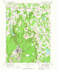 1946 Forest City1966 Print · USGSPost-war Susquehanna County is captured here as the coal and rail era transitions into a new chapter. Genealogists can trace family lines through Forest City and find rural landmarks like the Curtis Valley Sch or Maple Grove Cem.3 unique versions available
Showing maps 1-25 of 89
Top cities of Wayne County
- Honesdale historical maps
- Damascus Township historical maps
- Waymart historical maps
- Cherry Ridge Township historical maps
- South Canaan Township historical maps
- Dyberry Township historical maps
See more
Frequently asked questions
- What are the different types of historical maps available for Wayne County?
- What is the oldest map of Wayne County?
- Where can I purchase historical maps of Wayne County for my home or office?
- Where can I download high-res historical maps of Wayne County?
- Are there historical topographic maps available for Wayne County?
- Is there historical aerial imagery available for Wayne County?
- Where are historical maps of Wayne County sourced from?