1990s Maps of Wayne County, Pennsylvania
Explore 28 historic maps of Wayne County from the 1990s. These maps offer a rare glimpse into what life looked like during the 1990s — showing old roads, neighborhoods, homes, and landmarks that have changed or disappeared over time.
Whether you're researching your family's past, planning a metal detecting trip, or studying how Wayne County's landscape evolved across the 1990s, these high-resolution maps are a powerful tool for exploring the history of this region.
- Focus on a specific era: All maps on this page are from the 1990s, giving you a focused view of this time period.
- See what’s changed: Compare century-old streets, trails, and buildings to today's modern landscape using overlays and satellite layers.
- Research with precision: Use these maps for genealogy, historical research, land use analysis, or educational projects.
- View, download, or print: Maps are fully viewable online in high resolution, and can be downloaded or printed for your own records.
Start exploring Wayne County's history through authentic maps from the 1990s. This is your window into the past.
Wayne County, PA maps
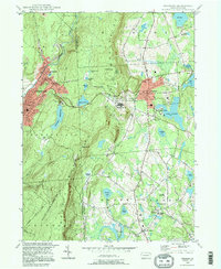
(28)- 1992 Map of Callicoon, 1994 Print
 1992 Callicoon1994 Print · USGSThe Upper Delaware River valley of New York and Pennsylvania is captured here in the early nineties, showing a landscape defined by river bends and high ridges. Genealogists can trace family roots through Holy Cross Cem, the streets of Hortonville, and the grounds of St Josephs Seminary.
 - 1992 Map of Long Eddy, 1995 Print
 1992 Long Eddy1995 Print · USGSAlong the Delaware River border in the early nineties, these valley and upland communities reflect a landscape defined by timber, stone, and recreation. Researchers can trace the layout of Equinunk, Long Eddy, and Pine Mill, or locate Union Church and Duck Harbor Pond.
 - 1992 Map of Newfoundland, 1995 Print
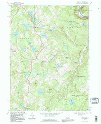
 1992 Newfoundland1995 Print · USGSThe headwaters of the Wallenpaupack in Wayne and Pike Counties appear here as a landscape of small villages and forested slopes in the early nineties. Researchers can trace family sites at Newfoundland, Haags Mill, and Angels, or locate old landmarks like Pine Grove Cem.
 - 1992 Map of Galilee, 1995 Print
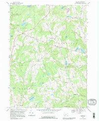 1992 Galilee1995 Print · USGSWayne County’s rural highlands appear here in the early nineties, showing a landscape of scattered farmsteads and glacial ponds. Genealogists can locate family landmarks like Hillcrest Cem or trace the early paths through Rileyville and West Damascus.
 - 1992 Map of Lake Como, 1995 Print
 1992 Lake Como1995 Print · USGSWayne County's lake country is captured here in the early 1990s, showing a landscape of seasonal camps and rural crossroads. Researchers can locate St Julianas Cem at Church Hill or trace the Old Railroad Grade near Dillontown.
 - 1992 Map of Orson, 1995 Print
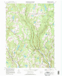
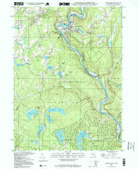
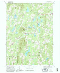 1992 Orson1995 Print · USGSHigh in the lake country of Wayne County in the early nineties, this survey captures the headwaters of the Lackawanna. Genealogists can find family landmarks like Orson Cem, Hines Corners, and Orson Ch along the winding mountain roads.
 - 1992 Map of Hancock, 1995 Print
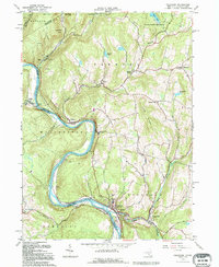
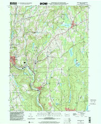
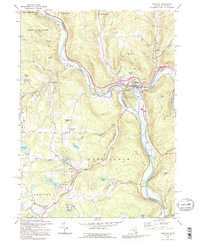 1992 Hancock1995 Print · USGSThe confluence of the Delaware River branches at the New York and Pennsylvania border highlights a landscape of river-town industry and highland lakes. Researchers can trace the rail lines through Hancock, locate family sites at Kingsbury Hill Cem, and explore the rural character of Starlight.2 unique versions available
 - 1993 Map of Damascus, 1995 Print
 1993 Damascus1995 Print · USGSThe Upper Delaware valley in the early nineties remains a quiet corridor of river towns and timbered hills along the Pennsylvania-New York line. Genealogists and local historians can trace family sites at Milanville, find the Township Sch, or locate rural markers like Skinners Falls and Overlook Cem.
 - 1994 Map of Hawley, 1995 Print
 1994 Hawley1995 Print · USGSThe Lake Wallenpaupack region is shown here in the mid-nineties as the community grew around the water's edge and the Lackawaxen River. Genealogists and local historians can trace family sites at Paupack Cem, Pine Grove Cem, and the old settlement of Wilsonville.
 - 1994 Map of Sterling, 1995 Print
 1994 Sterling1995 Print · USGSWayne and Lackawanna counties transitioned from traditional farming and mining to recreational residential hubs by the mid-1990s. Researchers can trace old family landmarks and local institutions like Peoples Ch, Drinker Sch, and the quiet Jericho Cem.
 - 1994 Map of Aldenville, 1995 Print
 1994 Aldenville1995 Print · USGSWayne County’s river valleys and glacial lakes are shown here in the mid-1990s, when historic turnpikes still connected small crossroad settlements. Researchers can trace family sites like Hulls Cem and St Cecelia Ch, or locate local landmarks like Tanners Falls and Aldenville.
 - 1994 Map of Narrowsburg, 1995 Print
 1994 Narrowsburg1995 Print · USGSThe Delaware River valley and its surrounding lake-strewn uplands are captured in the mid-1990s, highlighting the border communities between Pennsylvania and New York. Genealogists and local historians can trace family-named sites like Lava Cem, the St Francis Ch, and old river stops at Tusten Station.
 - 1994 Map of Buck Hill Falls, 1995 Print
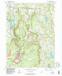
 1994 Buck Hill Falls1995 Print · USGSMonroe County was undergoing significant residential growth in the mid-1990s while maintaining its deep-rooted resort identity. Genealogists and local historians can trace family locations near Buck Hill Falls, Mountainhome, and St Anne Ch or locate landmarks like the Pocono Playhouse.
 - 1994 Map of Lake Ariel, 1995 Print
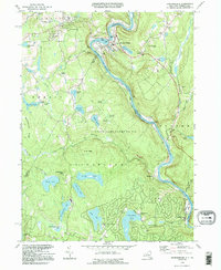
 1994 Lake Ariel1995 Print · USGSThe Lake Ariel region of Wayne County is captured here in the mid-1990s, showing a landscape defined by glacial ponds and small mountain hamlets. Researchers can trace family history through sites like Salem Cem, Wallenpaupack Mills, and the old rail paths of the Old RR Grade.
 - 1994 Map of Waymart, 1996 Print
 1994 Waymart1996 Print · USGSThe Moosic Mountains divide the industrial Lackawanna valley from the rural plateaus of Wayne County in the mid-1990s. Researchers can trace the anthracite heritage of Carbondale or find local landmarks like St Nicholas Seminary and Keen Lake.
 - 1994 Map of Lakeville, 1996 Print
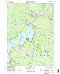
 1994 Lakeville1996 Print · USGSWayne County and Pike County meet along the western shore of Lake Wallenpaupack in the mid-1990s as the area's lake-centered communities continue to grow. Family historians can locate family-named landmarks and old rural sites like Tisdale Cem, St Marys Ch, and the settlement of Arlington.
 - 1994 Map of Forest City, 1996 Print
 1994 Forest City1996 Print · USGSNortheastern Pennsylvania’s high country near the turn of the millennium shows a landscape defined by the Lackawanna River and its upland reservoirs. Trace the historic Old Newburgh Turnpike and locate old family cemeteries like Maple Grove Cem and Sherwood Cem.
 - 1994 Map of Tobyhanna, 1996 Print
 1994 Tobyhanna1996 Print · USGSMonroe County was a hub of military logistics and Pocono recreation during the mid-nineties. Researchers can trace the layout of the Tobyhanna Army Depot, locate the Coolbaugh Sch, and explore the grounds of Camp Tegawitha.
 - 1997 Map of Thornhurst, 1998 Print
 1997 Thornhurst1998 Print · USGSThe Lehigh River valley and the Poconos plateau come into focus during the late nineties, showing a landscape shaped by conservation and seasonal recreation. Researchers can trace family sites at Clifton Cem or explore the wetlands of City of Rome Swamp and Bradys Lake.
 - 1997 Map of Narrowsburg, 1999 Print
 1997 Narrowsburg1999 Print · USGSThe Delaware River valley at the turn of the millennium shows a landscape shaped by the rail and river. You can trace the Erie tracks past Narrowsburg or locate the Lava Cem and St Francis Ch near the New York border.2 unique versions available
 - 1997 Map of Buck Hill Falls, 2000 Print
 1997 Buck Hill Falls2000 Print · USGSMonroe County enters the millennium as a premier mountain destination, balancing vast conservation lands with growing resort villages. Researchers can trace local development around Mountainhome, the Pocono Playhouse, and the historical church at St Anna Ch.
 - 1997 Map of Hawley, 2000 Print
 1997 Hawley2000 Print · USGSLake Wallenpaupack and the surrounding Poconos plateau are shown here as they appeared in the 1990s. Researchers can locate local landmarks like the Paupack Cem, Mt Bay Airstrip, and the Wallenpaupack Area High Sch.
 - 1997 Map of Sterling, 2000 Print
 1997 Sterling2000 Print · USGSWayne and Lackawanna counties appear here in the late twentieth century, showing a landscape of upland swamps and growing lakeside communities. Local researchers can locate family landmarks like Drinker Sch Cem, the Spring Hill Airpark, and the rural settlement at Madisonville.
 - 1999 Map of Newfoundland, 2001 Print
 1999 Newfoundland2001 Print · USGSThe Wallenpaupack Creek valley at the turn of the millennium shows a landscape of deep forests and quiet crossroads. Researchers can trace family sites at Zion Cem or explore established settlements like Newfoundland and South Sterling.
 - 1999 Map of White Mills, 2001 Print
 1999 White Mills2001 Print · USGSWayne County’s river valleys and lake districts are captured here at the close of the twentieth century. Genealogists and local historians can trace small-town life through landmarks like White Mills, the Vine Hill Cem, and St Josephs Ch.
Showing maps 1-25 of 28
Top cities of Wayne County
- Honesdale historical maps
- Damascus Township historical maps
- Waymart historical maps
- Cherry Ridge Township historical maps
- South Canaan Township historical maps
- Dyberry Township historical maps
See more
Frequently asked questions
- What are the different types of historical maps available for Wayne County?
- What is the oldest map of Wayne County?
- Where can I purchase historical maps of Wayne County for my home or office?
- Where can I download high-res historical maps of Wayne County?
- Are there historical topographic maps available for Wayne County?
- Is there historical aerial imagery available for Wayne County?
- Where are historical maps of Wayne County sourced from?