1990s Maps of Lebanon Township, Pennsylvania
Explore 4 historic maps of Lebanon Township from the 1990s. These maps offer a rare glimpse into what life looked like during the 1990s — showing old roads, neighborhoods, homes, and landmarks that have changed or disappeared over time.
Whether you're researching your family's past, planning a metal detecting trip, or studying how Lebanon Township's landscape evolved across the 1990s, these high-resolution maps are a powerful tool for exploring the history of this region.
- Focus on a specific era: All maps on this page are from the 1990s, giving you a focused view of this time period.
- See what’s changed: Compare century-old streets, trails, and buildings to today's modern landscape using overlays and satellite layers.
- Research with precision: Use these maps for genealogy, historical research, land use analysis, or educational projects.
- View, download, or print: Maps are fully viewable online in high resolution, and can be downloaded or printed for your own records.
Start exploring Lebanon Township's history through authentic maps from the 1990s. This is your window into the past.
Lebanon Township, PA maps
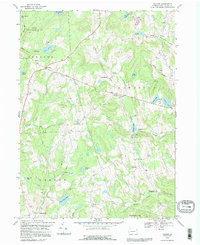
(4)- 1992 Map of Long Eddy, 1995 Print
 1992 Long Eddy1995 Print · USGSAlong the Delaware River border in the early nineties, these valley and upland communities reflect a landscape defined by timber, stone, and recreation. Researchers can trace the layout of Equinunk, Long Eddy, and Pine Mill, or locate Union Church and Duck Harbor Pond.
 - 1992 Map of Galilee, 1995 Print
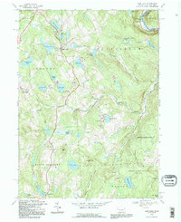
 1992 Galilee1995 Print · USGSWayne County’s rural highlands appear here in the early nineties, showing a landscape of scattered farmsteads and glacial ponds. Genealogists can locate family landmarks like Hillcrest Cem or trace the early paths through Rileyville and West Damascus.
 - 1992 Map of Lake Como, 1995 Print
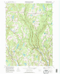
 1992 Lake Como1995 Print · USGSWayne County's lake country is captured here in the early 1990s, showing a landscape of seasonal camps and rural crossroads. Researchers can locate St Julianas Cem at Church Hill or trace the Old Railroad Grade near Dillontown.
 - 1994 Map of Aldenville, 1995 Print
 1994 Aldenville1995 Print · USGSWayne County’s river valleys and glacial lakes are shown here in the mid-1990s, when historic turnpikes still connected small crossroad settlements. Researchers can trace family sites like Hulls Cem and St Cecelia Ch, or locate local landmarks like Tanners Falls and Aldenville.
End of results
Showing maps 1-4 of 4
Top cities near Lebanon Township
- Carbondale historical maps
- Lackawaxen Township historical maps
- Honesdale historical maps
- Damascus Township historical maps
- Hancock historical maps
- Clifford Township historical maps
See more
Top neighborhoods of Lebanon Township
Frequently asked questions
- What are the different types of historical maps available for Lebanon Township?
- What is the oldest map of Lebanon Township?
- Where can I purchase historical maps of Lebanon Township for my home or office?
- Where can I download high-res historical maps of Lebanon Township?
- Are there historical topographic maps available for Lebanon Township?
- Is there historical aerial imagery available for Lebanon Township?
- Where are historical maps of Lebanon Township sourced from?