1960s Maps of Loyalhanna, Derry Township
Explore 3 historic maps of Loyalhanna from the 1960s. These maps offer a rare glimpse into what life looked like during the 1960s — showing old roads, neighborhoods, homes, and landmarks that have changed or disappeared over time.
Whether you're researching your family's past, planning a metal detecting trip, or studying how Loyalhanna's landscape evolved across the 1960s, these high-resolution maps are a powerful tool for exploring the history of this region.
- Focus on a specific era: All maps on this page are from the 1960s, giving you a focused view of this time period.
- See what’s changed: Compare century-old streets, trails, and buildings to today's modern landscape using overlays and satellite layers.
- Research with precision: Use these maps for genealogy, historical research, land use analysis, or educational projects.
- View, download, or print: Maps are fully viewable online in high resolution, and can be downloaded or printed for your own records.
Start exploring Loyalhanna's history through authentic maps from the 1960s. This is your window into the past.
Loyalhanna, Derry Township maps
(3)- 1964 Map of Pittsburgh
 1964 Pittsburgh1964 Print · USGSWestern Pennsylvania in the late fifties and early sixties shows a landscape of powerful river industries and expanding highways. Genealogists and historians can trace the rail corridors of the Pennsylvania RR through industrial hubs like Johnstown, Altoona, and Nanty Glo.
 - 1964 Map of Latrobe, 1965 Print
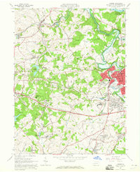 1964 Latrobe1965 Print · USGSLatrobe and its surrounding coal-patch towns are captured here in the mid-1960s during a peak of industrial and institutional activity. Trace the rail lines and mine sites that built towns like Hostetter and Luxor, or locate family sites near St Vincent College.5 unique versions available
 - 1964 Map of Derry, 1966 Print
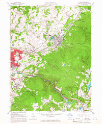 1964 Derry1966 Print · USGSDerry and Latrobe are shown in the mid-1960s during a period of heavy industrial activity and coal mining. Researchers can locate family landmarks such as St Martins Ch, Sacred Heart Sch, and numerous coal works including Coke Ovens and strip mines.4 unique versions available
End of results
Showing maps 1-3 of 3
Top cities near Loyalhanna
- Greensburg historical maps
- White historical maps
- Latrobe historical maps
- Mount Pleasant historical maps
- Blairsville historical maps
- Derry historical maps
See more
Top neighborhoods of Loyalhanna
- Snydertown historical maps
- Mechesneytown historical maps
- Cooperstown historical maps
- Pandora historical maps
Frequently asked questions
- What are the different types of historical maps available for Loyalhanna?
- What is the oldest map of Loyalhanna?
- Where can I purchase historical maps of Loyalhanna for my home or office?
- Where can I download high-res historical maps of Loyalhanna?
- Are there historical topographic maps available for Loyalhanna?
- Is there historical aerial imagery available for Loyalhanna?
- Where are historical maps of Loyalhanna sourced from?