1900-1909 Maps of Hempfield Township, Pennsylvania
Explore 6 historic maps of Hempfield Township from 1900-1909. These maps offer a rare glimpse into what life looked like during the 1900s — showing old roads, neighborhoods, homes, and landmarks that have changed or disappeared over time.
Whether you're researching your family's past, planning a metal detecting trip, or studying how Hempfield Township's landscape evolved across the 1900s, these high-resolution maps are a powerful tool for exploring the history of this region.
- Focus on a specific era: All maps on this page are from the 1900s, giving you a focused view of this time period.
- See what’s changed: Compare century-old streets, trails, and buildings to today's modern landscape using overlays and satellite layers.
- Research with precision: Use these maps for genealogy, historical research, land use analysis, or educational projects.
- View, download, or print: Maps are fully viewable online in high resolution, and can be downloaded or printed for your own records.
Start exploring Hempfield Township's history through authentic maps from the 1900s. This is your window into the past.
Hempfield Township, PA maps
(6)- 1900 Map of Latrobe, 1958 Print
 1900 Latrobe1958 Print · USGSThe industrial heart of Westmoreland County is shown at a pivotal moment when the coal and coke industry was reshaping the land. Genealogists and historians can trace the early layouts of Latrobe, Derry, and Blairsville alongside company towns like Whitney and Baggaley.
 - 1902 Map of Latrobe
 1902 Latrobe1902 Print · USGSWestmoreland County at the opening of the twentieth century was a powerhouse of the American coal and coke industry. Genealogists and industrial historians can trace the early rail networks of the Main Line and locate landmark sites like the St Vincent Monastery and various Coke Ovens.
 - 1902 Map of Connellsville
 1902 Connellsville1902 Print · USGSThe Pennsylvania coke region comes alive at the turn of the century as a labyrinth of coal mines and competing rail lines. Researchers can trace the industrial footprint of Star Mines, explore the river landings along the Youghiogheny River, and find old junctions like Bells Mills.5 unique versions available
 - 1903 Map of Latrobe, 1905 Print
 1903 Latrobe1905 Print · USGSWestmoreland County at the turn of the century reveals a landscape defined by the arrival of heavy industry and the winding Conemaugh River. Genealogists can locate family landmarks from the Coke Ovens at Crabtree to the grounds of St. Vincent.6 unique versions available
 - 1904 Map of Greensburg, 1963 Print
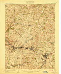
 1904 Greensburg1963 Print · USGSWestmoreland County at the dawn of the twentieth century was a landscape of industrial power and small-town growth. Genealogists can trace family footprints through Greensburg, find the Bulltown Schoolhouse, or follow the Pennsylvania Railroad through Jeannette and Manor.
 - 1906 Map of Greensburg
 1906 Greensburg1906 Print · USGSWestmoreland County at the height of its industrial growth is detailed here, showing a landscape defined by coal, glass, and rail. Researchers can trace ancestral roots at the Bulltown Schoolhouse or follow the early trolley and rail lines through Jeannette and Export.6 unique versions available
End of results
Showing maps 1-6 of 6
Top cities near Hempfield Township
- Penn Hills historical maps
- Monroeville historical maps
- Plum historical maps
- Greensburg historical maps
- White historical maps
- North Versailles historical maps
See more
Top neighborhoods of Hempfield Township
- Foxtown historical maps
- Whites Hill historical maps
- Weavers Old Stand historical maps
- Darragh historical maps
- Millersdale historical maps
- Edna Number One historical maps
See more
Frequently asked questions
- What are the different types of historical maps available for Hempfield Township?
- What is the oldest map of Hempfield Township?
- Where can I purchase historical maps of Hempfield Township for my home or office?
- Where can I download high-res historical maps of Hempfield Township?
- Are there historical topographic maps available for Hempfield Township?
- Is there historical aerial imagery available for Hempfield Township?
- Where are historical maps of Hempfield Township sourced from?