1990s Maps of Fort Allen, Hempfield Township
Explore 1 historic maps of Fort Allen from the 1990s. These maps offer a rare glimpse into what life looked like during the 1990s — showing old roads, neighborhoods, homes, and landmarks that have changed or disappeared over time.
Whether you're researching your family's past, planning a metal detecting trip, or studying how Fort Allen's landscape evolved across the 1990s, these high-resolution maps are a powerful tool for exploring the history of this region.
- Focus on a specific era: All maps on this page are from the 1990s, giving you a focused view of this time period.
- See what’s changed: Compare century-old streets, trails, and buildings to today's modern landscape using overlays and satellite layers.
- Research with precision: Use these maps for genealogy, historical research, land use analysis, or educational projects.
- View, download, or print: Maps are fully viewable online in high resolution, and can be downloaded or printed for your own records.
Start exploring Fort Allen's history through authentic maps from the 1990s. This is your window into the past.
Fort Allen, Hempfield Township maps
(1)- 1993 Map of Greensburg
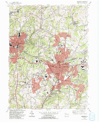 1993 Greensburg1993 Print · USGSGreensburg and the surrounding Westmoreland County boroughs are shown here in the early nineties during a period of significant commercial development. Researchers can trace historic sites like Old Hannastown Historical Park and Bushy Run Battlefield State Park alongside modern landmarks such as Greengate Mall and Seton Hill College.2 unique versions available
End of results
Showing maps 1-1 of 1
Top cities near Fort Allen
- Penn Hills historical maps
- Monroeville historical maps
- Plum historical maps
- Greensburg historical maps
- White historical maps
- North Versailles historical maps
See more
Frequently asked questions
- What are the different types of historical maps available for Fort Allen?
- What is the oldest map of Fort Allen?
- Where can I purchase historical maps of Fort Allen for my home or office?
- Where can I download high-res historical maps of Fort Allen?
- Are there historical topographic maps available for Fort Allen?
- Is there historical aerial imagery available for Fort Allen?
- Where are historical maps of Fort Allen sourced from?