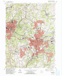
1993 Map of Greensburg
USGS Topo · Published 1993About this map
The Bushy Run Battlefield State Park sits at the northern edge of this Westmoreland County landscape, marking a pivotal site of the 1763 Pontiac's War. By the early 1990s, the region shows a dense network of suburban and commercial expansion surrounding Greensburg, evidenced by the prominent Greengate Mall and Westmoreland Mall. Despite this growth, older industrial and colonial roots remain visible through features like the Old Hannastown Historical Park and numerous mine-related labels such as Mine Dump near Forbes Road.
Find a feature on this map
69 named features on this map. Tap any name to fly to it.
Don’t see what you’re looking for? This feature index may not catch every label — zoom into the map to look around manually.
Map Details
Editions of this 1993 Greensburg Map
2 editions found
Other maps of this area

1900 · Latrobe
USGS Topo · 1:62,500

1902 · Latrobe
USGS Topo · 1:62,500

1902 · Connellsville
USGS Topo · 1:62,500

1903 · Latrobe
USGS Topo · 1:62,500

1904 · Greensburg
USGS Topo · 1:62,500

1906 · Greensburg
USGS Topo · 1:62,500

1922 · Donegal
USGS Topo · 1:62,500

1931 · Connellsville
USGS Topo · 1:62,500

1935 · Donegal
USGS Topo · 1:62,500

1936 · Connellsville
USGS Topo · 1:62,500
Featured Places
- Greensburg, PA
- Jeannette, PA
- Southwest Greensburg, PA
- South Greensburg, PA
- Grapeville, Hempfield Township