1900-1909 Maps of Camp Jo-Ann, Murrysville
Explore 2 historic maps of Camp Jo-Ann from 1900-1909. These maps offer a rare glimpse into what life looked like during the 1900s — showing old roads, neighborhoods, homes, and landmarks that have changed or disappeared over time.
Whether you're researching your family's past, planning a metal detecting trip, or studying how Camp Jo-Ann's landscape evolved across the 1900s, these high-resolution maps are a powerful tool for exploring the history of this region.
- Focus on a specific era: All maps on this page are from the 1900s, giving you a focused view of this time period.
- See what’s changed: Compare century-old streets, trails, and buildings to today's modern landscape using overlays and satellite layers.
- Research with precision: Use these maps for genealogy, historical research, land use analysis, or educational projects.
- View, download, or print: Maps are fully viewable online in high resolution, and can be downloaded or printed for your own records.
Start exploring Camp Jo-Ann's history through authentic maps from the 1900s. This is your window into the past.
Camp Jo-Ann, Murrysville maps
(2)- 1907 Map of Freeport, 1956 Print
 1907 Freeport1956 Print · USGSThe industrial river valleys of Armstrong, Westmoreland, and Butler counties come alive in this early 1900s survey. Genealogists and researchers can trace the rail-and-river network through Freeport and Schenley, locating old post offices at Garvers Ferry and Dime.
 - 1909 Map of Freeport
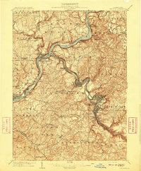 1909 Freeport1909 Print · USGSThe industrial river valleys of the Allegheny and Kiskiminitas are captured here during the peak of Pennsylvania's rail-and-river era. Researchers can trace the early layouts of Freeport and Leechburg or locate vanished sites like the Lucesco PO.5 unique versions available
End of results
Showing maps 1-2 of 2
Top cities near Camp Jo-Ann
- Pittsburgh historical maps
- Penn Hills historical maps
- Monroeville historical maps
- Plum historical maps
- McKeesport historical maps
- West Mifflin historical maps
See more
Frequently asked questions
- What are the different types of historical maps available for Camp Jo-Ann?
- What is the oldest map of Camp Jo-Ann?
- Where can I purchase historical maps of Camp Jo-Ann for my home or office?
- Where can I download high-res historical maps of Camp Jo-Ann?
- Are there historical topographic maps available for Camp Jo-Ann?
- Is there historical aerial imagery available for Camp Jo-Ann?
- Where are historical maps of Camp Jo-Ann sourced from?