1990s Maps of Conewago Township, Pennsylvania
Explore 2 historic maps of Conewago Township from the 1990s. These maps offer a rare glimpse into what life looked like during the 1990s — showing old roads, neighborhoods, homes, and landmarks that have changed or disappeared over time.
Whether you're researching your family's past, planning a metal detecting trip, or studying how Conewago Township's landscape evolved across the 1990s, these high-resolution maps are a powerful tool for exploring the history of this region.
- Focus on a specific era: All maps on this page are from the 1990s, giving you a focused view of this time period.
- See what’s changed: Compare century-old streets, trails, and buildings to today's modern landscape using overlays and satellite layers.
- Research with precision: Use these maps for genealogy, historical research, land use analysis, or educational projects.
- View, download, or print: Maps are fully viewable online in high resolution, and can be downloaded or printed for your own records.
Start exploring Conewago Township's history through authentic maps from the 1990s. This is your window into the past.
Conewago Township, PA maps
(2)- 1999 Map of Dover, 2001 Print
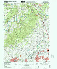 1999 Dover2001 Print · USGSNorthern York County at the end of the century shows a blend of suburban growth and traditional rural landscapes. Trace local history through landmark sites like Susquehanna Speedway, Zions View, and historic country churches like St James Ch.
 - 1999 Map of York Haven, 2001 Print
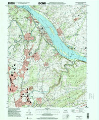 1999 York Haven2001 Print · USGSThe Susquehanna River corridor at the end of the twentieth century shows a blend of industrial legacy and growing residential communities. Genealogists and historians can locate family landmarks like Haldeman Cem, the historic Codorus Furnace, and Mundis Mill.
End of results
Showing maps 1-2 of 2
Top cities near Conewago Township
- Harrisburg historical maps
- York historical maps
- Hanover historical maps
- Hershey historical maps
- Elizabethtown historical maps
- Middletown historical maps
See more
Top neighborhoods of Conewago Township
- Andersontown historical maps
- Eastmont historical maps
- Strinestown historical maps
- Zions View historical maps
Frequently asked questions
- What are the different types of historical maps available for Conewago Township?
- What is the oldest map of Conewago Township?
- Where can I purchase historical maps of Conewago Township for my home or office?
- Where can I download high-res historical maps of Conewago Township?
- Are there historical topographic maps available for Conewago Township?
- Is there historical aerial imagery available for Conewago Township?
- Where are historical maps of Conewago Township sourced from?