1940s Maps of Shrewsbury Township, Pennsylvania
Explore 4 historic maps of Shrewsbury Township from the 1940s. These maps offer a rare glimpse into what life looked like during the 1940s — showing old roads, neighborhoods, homes, and landmarks that have changed or disappeared over time.
Whether you're researching your family's past, planning a metal detecting trip, or studying how Shrewsbury Township's landscape evolved across the 1940s, these high-resolution maps are a powerful tool for exploring the history of this region.
- Focus on a specific era: All maps on this page are from the 1940s, giving you a focused view of this time period.
- See what’s changed: Compare century-old streets, trails, and buildings to today's modern landscape using overlays and satellite layers.
- Research with precision: Use these maps for genealogy, historical research, land use analysis, or educational projects.
- View, download, or print: Maps are fully viewable online in high resolution, and can be downloaded or printed for your own records.
Start exploring Shrewsbury Township's history through authentic maps from the 1940s. This is your window into the past.
Shrewsbury Township, PA maps
(4)- 1944 Map of New Freedom
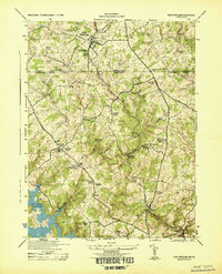 1944 New Freedom1944 Print · USGSThe Pennsylvania-Maryland border during the mid-forties reveals a rural landscape of tight-knit communities centered on the Pennsylvania Railroad. Genealogists and historians can trace the foundations of local life through the Summit Grove Camp Meeting, Bentley Springs, and the 6th District Consolidated School.
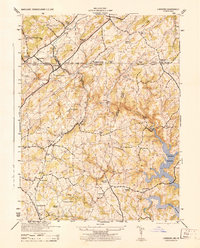
 - 1944 Map of Norrisville
 1944 Norrisville1944 Print · USGSMaryland and Pennsylvania borderlands meet along the Mason and Dixon Line during the mid-1940s. Genealogists and researchers can trace rural life through landmarks like Ivory Mill, Ebaughs School, and the McKendree Church.
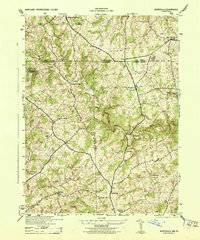
 - 1944 Map of Lineboro
 1944 Lineboro1944 Print · USGSMaryland and Pennsylvania border life is captured here in the mid-1940s, centered on the Mason and Dixon Line. Researchers can trace rural genealogy and land use through landmarks like Baughmans Mill, Stiltz, and the Blackrock Chapel & School.
 - 1948 Map of Baltimore
 1948 Baltimore1948 Print · USGSMaryland and Pennsylvania crossroads are captured in the late 1940s, showing a landscape defined by historic rail lines and major military installations. Genealogists can trace family connections in Gettysburg, Westminster, and near the U.S. Naval Academy in Annapolis.2 unique versions available
End of results
Showing maps 1-4 of 4
Top cities near Shrewsbury Township
- York historical maps
- West Manheim Township historical maps
- Shrewsbury historical maps
- Hampstead historical maps
- Red Lion historical maps
- Manchester historical maps
See more
Top neighborhoods of Shrewsbury Township
- Hildebrand historical maps
- Bonnair historical maps
- Hametown historical maps
- Keeney historical maps
- Tolna historical maps
- Centerville historical maps
See more
Frequently asked questions
- What are the different types of historical maps available for Shrewsbury Township?
- What is the oldest map of Shrewsbury Township?
- Where can I purchase historical maps of Shrewsbury Township for my home or office?
- Where can I download high-res historical maps of Shrewsbury Township?
- Are there historical topographic maps available for Shrewsbury Township?
- Is there historical aerial imagery available for Shrewsbury Township?
- Where are historical maps of Shrewsbury Township sourced from?