1990s Maps of York Township, Pennsylvania
Explore 5 historic maps of York Township from the 1990s. These maps offer a rare glimpse into what life looked like during the 1990s — showing old roads, neighborhoods, homes, and landmarks that have changed or disappeared over time.
Whether you're researching your family's past, planning a metal detecting trip, or studying how York Township's landscape evolved across the 1990s, these high-resolution maps are a powerful tool for exploring the history of this region.
- Focus on a specific era: All maps on this page are from the 1990s, giving you a focused view of this time period.
- See what’s changed: Compare century-old streets, trails, and buildings to today's modern landscape using overlays and satellite layers.
- Research with precision: Use these maps for genealogy, historical research, land use analysis, or educational projects.
- View, download, or print: Maps are fully viewable online in high resolution, and can be downloaded or printed for your own records.
Start exploring York Township's history through authentic maps from the 1990s. This is your window into the past.
York Township, PA maps
(5)- 1998 Map of West York, 2000 Print
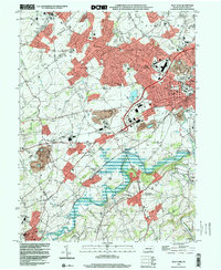 1998 West York2000 Print · USGSWest York and its surrounding townships show the transition from rural landscape to suburban growth in the late nineties. Genealogists and historians can trace family locations through Strayers Cem, visit old school sites like Boyer Sch, and locate the New Salem (York New Salem PO).
 - 1999 Map of York, 2001 Print
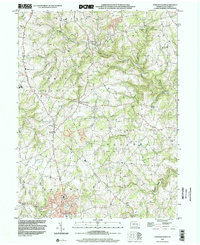
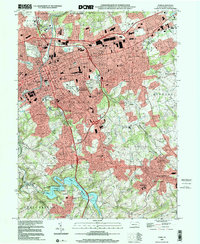 1999 York2001 Print · USGSYork and its surrounding boroughs are captured at the close of the twentieth century, showing a transition from dense urban centers to burgeoning suburban valleys. Trace local history through family landmarks like Reynolds Mill, old burial grounds such as Stump Cem, and the historic Lincoln Highway.
 - 1999 Map of Glen Rock, 2001 Print
 1999 Glen Rock2001 Print · USGSSouthern York County at the end of the twentieth century shows a landscape of historic boroughs linked by winding creeks and modern interchanges. Genealogists and local historians can trace family sites at Friedensaal Ch Cem, the borough of Glen Rock, and the aptly named village of Railroad.
 - 1999 Map of Red Lion, 2002 Print
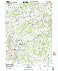 1999 Red Lion2002 Print · USGSYork County at the close of the twentieth century reveals a landscape shaped by early industry and community nodes like Red Lion and Hallam. Genealogists and historians can trace family roots through numerous sites including Margaretta Furnace, Mazie Gable Sch Cem, and Leiphart Mill.
 - 1999 Map of Stewartstown, 2002 Print
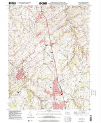
 1999 Stewartstown2002 Print · USGSSouthern York County's agrarian landscape is preserved here as it appeared in the late twentieth century, centered on the hub of Stewartstown. Researchers can trace the legacy of local industry through family-named landmarks like Sechrist Mill, Hyson Mill, and Grove Mill.
End of results
Showing maps 1-5 of 5
Top cities near York Township
- York historical maps
- Elizabethtown historical maps
- Columbia historical maps
- Mount Joy historical maps
- West Manheim Township historical maps
- Shrewsbury historical maps
See more
Top neighborhoods of York Township
- Ore Valley historical maps
- Queens Gate historical maps
- Rye historical maps
- Spry historical maps
- Chapel Church historical maps
- Arbor historical maps
See more
Frequently asked questions
- What are the different types of historical maps available for York Township?
- What is the oldest map of York Township?
- Where can I purchase historical maps of York Township for my home or office?
- Where can I download high-res historical maps of York Township?
- Are there historical topographic maps available for York Township?
- Is there historical aerial imagery available for York Township?
- Where are historical maps of York Township sourced from?