1900s (20th Century) Maps of Briggs Corner, East Greenwich
Explore 12 historic maps of Briggs Corner from the 1900s (20th Century). These maps offer a rare glimpse into what life looked like during the 1900s — showing old roads, neighborhoods, homes, and landmarks that have changed or disappeared over time.
Whether you're researching your family's past, planning a metal detecting trip, or studying how Briggs Corner's landscape evolved across the 1900s, these high-resolution maps are a powerful tool for exploring the history of this region.
- Focus on a specific era: All maps on this page are from the 1900s, giving you a focused view of this time period.
- See what’s changed: Compare century-old streets, trails, and buildings to today's modern landscape using overlays and satellite layers.
- Research with precision: Use these maps for genealogy, historical research, land use analysis, or educational projects.
- View, download, or print: Maps are fully viewable online in high resolution, and can be downloaded or printed for your own records.
Start exploring Briggs Corner's history through authentic maps from the 1900s. This is your window into the past.
Briggs Corner, East Greenwich maps
(12)- 1919 Map of Narragansett Bay, 1921 Print
 1919 Narragansett Bay1921 Print · USGSThe Rhode Island coast thrived as a hub of rail and maritime activity during the early twentieth century. Genealogists and historians can trace rail lines like the Sea View Electric R.R. and locate old landmarks like the Portsmouth Coal Mines and State Farm.2 unique versions available
 - 1942 Map of Wickford, 1957 Print
 1942 Wickford1957 Print · USGSWickford and the West Passage are captured here just as modern transit began to reshape the coastline. Genealogists can trace family names at Quidnessett Cem and Allenton Cem or locate homes near Wickford Junction and Hamilton.
 - 1943 Map of Providence
 1943 Providence1943 Print · USGSNarragansett Bay and the industrial Blackstone Valley appear here in the midst of the Second World War. Genealogists and researchers can trace local landmarks like Lonsdale Station, the St Marys Reservoir, and the Rhode Island State Airport.
 - 1944 Map of Wickford
 1944 Wickford1944 Print · USGSCoastal Washington County is seen here during the mid-1940s, as the region’s maritime and rail networks were at their peak. Genealogists and historians can trace family locations near Wickford, Allenton, and Bridges Corner, or locate the historic Fort Greble on Dutch Island.2 unique versions available
 - 1947 Map of Providence, 1948 Print
 1947 Providence1948 Print · USGSSouthern New England is captured in the mid-1940s, showing a landscape defined by busy industrial ports and expanding military installations. Researchers can trace the rail lines of the N.Y. N.H. & H. RR or locate coastal defenses like Fort Adams and Quonset Point.5 unique versions available
 - 1948 Map of Providence, 1951 Print
 1948 Providence1951 Print · USGSSouthern New England’s coastal reaches are captured here in the late 1940s, from the industrial heart of Providence to the tip of Provincetown. Genealogists and historians can trace rail lines like the Central Vermont Railway and locate active military sites such as Otis Air Force Base and Fort Rodman.
 - 1957 Map of Providence
 1957 Providence1957 Print · USGSCoastal New England at the height of the mid-century era shows a landscape shaped by maritime industry and Cold War defense. Genealogists and historians can trace the reach of the New York, New Haven & Hartford RR and locate legacy sites like Fort Adams and Quonset Point Naval Air Station.
 - 1957 Map of Wickford, 1959 Print
 1957 Wickford1959 Print · USGSThe Narragansett Bay shoreline in the late fifties shows a landscape of massive naval installations and quiet historic villages. Researchers can find coastal landmarks like the Plum Beach Lighthouse, family burial sites such as Ayrault Cem, and the path of the New York New Haven and Hartford RR.4 unique versions available
 - 1958 Map of Providence
 1958 Providence1958 Print · USGSThe Rhode Island and Massachusetts coastlines are shown in detail during the late 1950s, from the urban cores to the tips of the islands. Researchers can trace the mid-century footprint of Quonset Point Naval Air Station, the defense works at Fort Adams, and the rail network of the New York, New Haven and Hartford RR.
 - 1963 Map of Providence
 1963 Providence1963 Print · USGSSouthern New England's coastal and industrial heartland is captured here in the early sixties, from the Rhode Island mainland to the far reaches of the Cape. Researchers can trace mid-century growth in Providence or locate landmarks on Marthas Vineyard and Nantucket Island.
 - 1984 Map of Providence, 1985 Print
 1984 Providence1985 Print · USGSThe Rhode Island coast and its industrial heartlands are captured here in the mid-eighties, showing the density of the Providence metro area. Researchers can trace historic rail lines like the Providence & Worcester RR and explore the maritime layout of Narragansett Bay and Newport.
 - 1995 Map of Wickford, 1999 Print
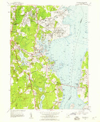
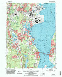 1995 Wickford1999 Print · USGSThe North Kingstown coastline in the mid-1990s shows the bustling maritime economy and naval presence of the West Passage. Genealogists and local historians can trace legacy sites like Quidnessett Cem, the Wickford Lighthouse, and the old rail hub at Wickford Junction.
End of results
Showing maps 1-12 of 12
Frequently asked questions
- What are the different types of historical maps available for Briggs Corner?
- What is the oldest map of Briggs Corner?
- Where can I purchase historical maps of Briggs Corner for my home or office?
- Where can I download high-res historical maps of Briggs Corner?
- Are there historical topographic maps available for Briggs Corner?
- Is there historical aerial imagery available for Briggs Corner?
- Where are historical maps of Briggs Corner sourced from?