1950s Maps of Burrillville, Rhode Island
Explore 10 historic maps of Burrillville from the 1950s. These maps offer a rare glimpse into what life looked like during the 1950s — showing old roads, neighborhoods, homes, and landmarks that have changed or disappeared over time.
Whether you're researching your family's past, planning a metal detecting trip, or studying how Burrillville's landscape evolved across the 1950s, these high-resolution maps are a powerful tool for exploring the history of this region.
- Focus on a specific era: All maps on this page are from the 1950s, giving you a focused view of this time period.
- See what’s changed: Compare century-old streets, trails, and buildings to today's modern landscape using overlays and satellite layers.
- Research with precision: Use these maps for genealogy, historical research, land use analysis, or educational projects.
- View, download, or print: Maps are fully viewable online in high resolution, and can be downloaded or printed for your own records.
Start exploring Burrillville's history through authentic maps from the 1950s. This is your window into the past.
Burrillville, RI maps
(10)- 1953 Map of Blackstone, 1954 Print
 1953 Blackstone1954 Print · USGSThe industrial corridor between Mendon and Woonsocket comes alive in this mid-century survey of the Blackstone River valley. Local historians can trace the paths of the New York New Haven and Hartford railroad through family landmarks like the Chestnut Hill Meeting House and Draper Airfield.4 unique versions available
 - 1953 Map of Oxford, 1954 Print
 1953 Oxford1954 Print · USGSSouthern Worcester County was a busy intersection of industry and nature in the early fifties. Trace the rail lines of the New York New Haven and Hartford and locate landmarks like the St Joseph Cem and the sprawling Lake Chaubunagungamaug.3 unique versions available
 - 1953 Map of Uxbridge, 1955 Print
 1953 Uxbridge1955 Print · USGSThe Blackstone Valley villages of the mid-twentieth century are captured here alongside the rural borderlands of Rhode Island. Genealogists can trace family heritage through the Aldrich and Buffum cemeteries or locate the Tasseltop Sch.3 unique versions available
 - 1954 Map of Georgiaville, 1956 Print
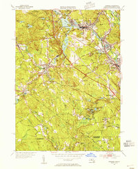
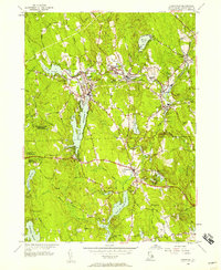
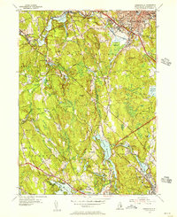 1954 Georgiaville1956 Print · USGSNorthern Rhode Island in the mid-fifties is captured here during a period of industrial activity along the Woonasquatucket. Trace family history through Union Cem and The Shrine, or locate old rail stops at Tarkiln and Primrose.5 unique versions available
 - 1955 Map of Thompson, 1957 Print
 1955 Thompson1957 Print · USGSNortheastern Connecticut and the Rhode Island border are captured here in the mid-fifties, showing a landscape of scattered mill villages and expansive state forests. Genealogists and local historians can trace family roots at Dike Cem or locate old community hubs like East Putnam and Ballouville.2 unique versions available
 - 1955 Map of Chepachet, 1957 Print
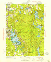
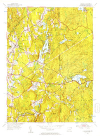
 1955 Chepachet1957 Print · USGSProvidence County’s mill towns and reservoir systems are preserved here in the mid-fifties. Genealogists and hikers can trace the New York New Haven and Hartford Railroad and explore landmarks like Acote Hill or Burrillville High Sch.5 unique versions available
 - 1956 Map of Boston, 1967 Print
 1956 Boston1967 Print · USGSThe Massachusetts coastline and industrial interior are seen here during the mid-century peak of suburban and highway expansion. Researchers can trace historic harbor defenses like Fort Revere, local landmarks such as Faneuil Hall, and the vast Parker River National Wildlife Refuge.6 unique versions available
 - 1957 Map of Providence
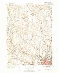
 1957 Providence1957 Print · USGSCoastal New England at the height of the mid-century era shows a landscape shaped by maritime industry and Cold War defense. Genealogists and historians can trace the reach of the New York, New Haven & Hartford RR and locate legacy sites like Fort Adams and Quonset Point Naval Air Station.
 - 1958 Map of Boston
 1958 Boston1958 Print · USGSEastern Massachusetts and southern New Hampshire are shown at the height of the industrial era, before the full expansion of the interstate system. Trace coastal defenses at Fort Warren, historic rail lines like the Boston and Maine, and the development of the Mass. 128 corridor.2 unique versions available
 - 1958 Map of Providence
 1958 Providence1958 Print · USGSThe Rhode Island and Massachusetts coastlines are shown in detail during the late 1950s, from the urban cores to the tips of the islands. Researchers can trace the mid-century footprint of Quonset Point Naval Air Station, the defense works at Fort Adams, and the rail network of the New York, New Haven and Hartford RR.
End of results
Showing maps 1-10 of 10
Top cities near Burrillville
- Providence historical maps
- Warwick historical maps
- Cranston historical maps
- Woonsocket historical maps
- Cumberland historical maps
- North Providence historical maps
See more
Top neighborhoods of Burrillville
- Oakland historical maps
- Pascoag historical maps
- Glendale historical maps
- Harrisville historical maps
- Mapleville historical maps
- Huntsville historical maps
See more
Frequently asked questions
- What are the different types of historical maps available for Burrillville?
- What is the oldest map of Burrillville?
- Where can I purchase historical maps of Burrillville for my home or office?
- Where can I download high-res historical maps of Burrillville?
- Are there historical topographic maps available for Burrillville?
- Is there historical aerial imagery available for Burrillville?
- Where are historical maps of Burrillville sourced from?