1950s Maps of Johns Island, South Carolina
Explore 5 historic maps of Johns Island from the 1950s. These maps offer a rare glimpse into what life looked like during the 1950s — showing old roads, neighborhoods, homes, and landmarks that have changed or disappeared over time.
Whether you're researching your family's past, planning a metal detecting trip, or studying how Johns Island's landscape evolved across the 1950s, these high-resolution maps are a powerful tool for exploring the history of this region.
- Focus on a specific era: All maps on this page are from the 1950s, giving you a focused view of this time period.
- See what’s changed: Compare century-old streets, trails, and buildings to today's modern landscape using overlays and satellite layers.
- Research with precision: Use these maps for genealogy, historical research, land use analysis, or educational projects.
- View, download, or print: Maps are fully viewable online in high resolution, and can be downloaded or printed for your own records.
Start exploring Johns Island's history through authentic maps from the 1950s. This is your window into the past.
Johns Island, SC maps
(5)- 1957 Map of Savannah, 1967 Print
 1957 Savannah1967 Print · USGSThe Lowcountry and Georgia coastal plain are shown here in the late fifties, prior to modern expansion. Researchers can trace the rail-and-river economy through the Central of Georgia lines and the Ogeechee River wetlands.4 unique versions available
 - 1958 Map of Johns Island, 1959 Print
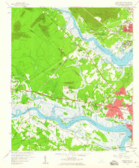 1958 Johns Island1959 Print · USGSThe Lowcountry landscape west of Charleston comes to life in the late fifties, showing a mix of historic river estates and postwar growth. Genealogists and historians can trace local landmarks like Drayton Hall, Fort Bull, and the Stono Sta rail stop.5 unique versions available
 - 1959 Map of Legareville, 1960 Print
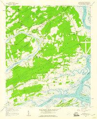 1959 Legareville1960 Print · USGSJohns Island and the surrounding South Carolina Lowcountry are captured in the late fifties, showing a rural landscape of tidal creeks and church-centered communities. Genealogists and historians can trace family locations near Legareville, Fenwick Crossroads, and several schools including Haut Gap Sch.3 unique versions available
 - 1959 Map of James Island, 1960 Print
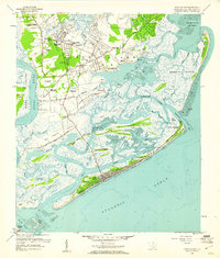 1959 James Island1960 Print · USGSThe coastal marshlands and barrier islands of the Charleston area are captured here during a period of mid-century growth. Genealogists and historians can trace family-named sites and landmarks like Secessionville, Sol Legare Island, and the Loran Coast Guard Station.4 unique versions available
 - 1959 Map of Kiawah Island, 1960 Print
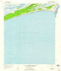 1959 Kiawah Island1960 Print · USGSCoastal South Carolina remains largely untouched in the late fifties, prior to the island's modern development. Trace the original footprints of Kiawah Island Drive and the natural winding paths of Cinder Creek and the Kiawah River.3 unique versions available
End of results
Showing maps 1-5 of 5
Top cities near Johns Island
- Charleston historical maps
- North Charleston historical maps
- Mount Pleasant historical maps
- Goose Creek historical maps
- Hanahan historical maps
- Hollywood historical maps
See more
Top neighborhoods of Johns Island
- Cedar Springs historical maps
- Fenwick Crossroads historical maps
- Fenwick Hills historical maps
- Humbert Woods historical maps
- Huskum Corner Cross Roads historical maps
- Point Park Estates historical maps
See more
Frequently asked questions
- What are the different types of historical maps available for Johns Island?
- What is the oldest map of Johns Island?
- Where can I purchase historical maps of Johns Island for my home or office?
- Where can I download high-res historical maps of Johns Island?
- Are there historical topographic maps available for Johns Island?
- Is there historical aerial imagery available for Johns Island?
- Where are historical maps of Johns Island sourced from?