1960s Maps of Johns Island, South Carolina
Explore 7 historic maps of Johns Island from the 1960s. These maps offer a rare glimpse into what life looked like during the 1960s — showing old roads, neighborhoods, homes, and landmarks that have changed or disappeared over time.
Whether you're researching your family's past, planning a metal detecting trip, or studying how Johns Island's landscape evolved across the 1960s, these high-resolution maps are a powerful tool for exploring the history of this region.
- Focus on a specific era: All maps on this page are from the 1960s, giving you a focused view of this time period.
- See what’s changed: Compare century-old streets, trails, and buildings to today's modern landscape using overlays and satellite layers.
- Research with precision: Use these maps for genealogy, historical research, land use analysis, or educational projects.
- View, download, or print: Maps are fully viewable online in high resolution, and can be downloaded or printed for your own records.
Start exploring Johns Island's history through authentic maps from the 1960s. This is your window into the past.
Johns Island, SC maps
(7)- 1960 Map of Savannah
 1960 Savannah1960 Print · USGSCoastal Georgia and the South Carolina Lowcountry are captured in the late fifties, showcasing the intricate web of islands and tidal rivers before modern expansion. Researchers can trace the rail lines of the Atlantic Coast Line or locate sites like Parris Island, Beaufort, and the Tybee Lighthouse.
 - 1960 Map of Ravenel, 1964 Print
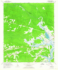 1960 Ravenel1964 Print · USGSCoastal South Carolina's Lowcountry is captured here in the early 1960s, showing a landscape defined by rail lines and tidal swamps. Researchers can locate family landmarks like Miley Hill Sch, St Pauls Ch Cem, and the crossing at Rantowles.4 unique versions available
 - 1960 Map of Wadmalaw Island, 1964 Print
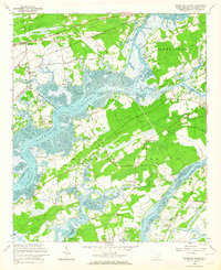 1960 Wadmalaw Island1964 Print · USGSCoastal South Carolina in the early sixties reveals a landscape of tidal islands and rail-connected settlements before modern development. Genealogists can trace family roots through numerous local landmarks like Wadmalaw Sch, St Marys Ch, and Chaplin Cem.2 unique versions available
 - 1960 Map of Rockville, 1964 Print
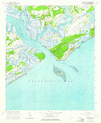 1960 Rockville1964 Print · USGSThe South Carolina Lowcountry remains a world of winding tidal creeks and quiet island settlements during the early 1960s. Genealogists and local historians can trace the foundations of Rockville and Rockland or locate St Johns Ch and the coastal landmarks of Seabrook Island.4 unique versions available
 - 1961 Map of Savannah
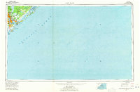
 1961 Savannah1961 Print · USGSThe Georgia and South Carolina Lowcountry comes alive in this mid-century survey of coastal marshes, barrier islands, and river networks. Genealogists and historians can trace the paths of the Seaboard Air Line RR, locate family sites near Isle of Hope, or study the grounds of Fort Stewart Military Reservation.2 unique versions available
 - 1968 Map of James Island
 1968 James Island1968 Print · USGSThe South Carolina Lowcountry in the late sixties shows a transition between its historic coastal defenses and modern expansion. Trace the harbor landscape from Charleston to the barrier islands, finding landmarks like Fort Sumter, Fort Moultrie, and Carolina Skyways.
 - 1969 Map of James Island, 1971 Print
 1969 James Island1971 Print · USGSThe South Carolina coast and Charleston Harbor are documented here in the late sixties, showing a landscape defined by naval history and barrier island growth. Genealogists and historians can trace the footprint of Scanlonville, Folly Beach, and the historic Ft Moultrie.2 unique versions available
End of results
Showing maps 1-7 of 7
Top cities near Johns Island
- Charleston historical maps
- North Charleston historical maps
- Mount Pleasant historical maps
- Goose Creek historical maps
- Hanahan historical maps
- Hollywood historical maps
See more
Top neighborhoods of Johns Island
- Cedar Springs historical maps
- Fenwick Crossroads historical maps
- Fenwick Hills historical maps
- Humbert Woods historical maps
- Huskum Corner Cross Roads historical maps
- Point Park Estates historical maps
See more
Frequently asked questions
- What are the different types of historical maps available for Johns Island?
- What is the oldest map of Johns Island?
- Where can I purchase historical maps of Johns Island for my home or office?
- Where can I download high-res historical maps of Johns Island?
- Are there historical topographic maps available for Johns Island?
- Is there historical aerial imagery available for Johns Island?
- Where are historical maps of Johns Island sourced from?