1940s Maps of Cooper Estates, Mount Pleasant
Explore 3 historic maps of Cooper Estates from the 1940s. These maps offer a rare glimpse into what life looked like during the 1940s — showing old roads, neighborhoods, homes, and landmarks that have changed or disappeared over time.
Whether you're researching your family's past, planning a metal detecting trip, or studying how Cooper Estates's landscape evolved across the 1940s, these high-resolution maps are a powerful tool for exploring the history of this region.
- Focus on a specific era: All maps on this page are from the 1940s, giving you a focused view of this time period.
- See what’s changed: Compare century-old streets, trails, and buildings to today's modern landscape using overlays and satellite layers.
- Research with precision: Use these maps for genealogy, historical research, land use analysis, or educational projects.
- View, download, or print: Maps are fully viewable online in high resolution, and can be downloaded or printed for your own records.
Start exploring Cooper Estates's history through authentic maps from the 1940s. This is your window into the past.
Cooper Estates, Mount Pleasant maps
(3)- 1943 Map of Fort Moultrie
 1943 Fort Moultrie1943 Print · USGSThe Charleston coast at the height of the war reveals a landscape of tactical significance and growing seaside communities. Genealogists and historians can trace old homesteads near Porchers Bluff or locate the Atlanticville P O and Sevenmile Sch.2 unique versions available
 - 1948 Map of James Island
 1948 James Island1948 Print · USGSThe South Carolina coast around the harbor city appeared in this postwar period as a network of naval defenses and established sea island communities. Trace the roads and waterways connecting Charleston to Fort Sumter, Mt Pleasant, and the Isle of Palms.2 unique versions available
 - 1948 Map of Charleston
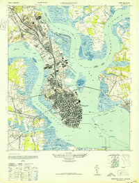 1948 Charleston1948 Print · USGSCharleston’s peninsula and harbor are shown at their mid-century industrial peak, from the historic city core to the sprawling naval works. Genealogists and historians can trace old settlements like Fourmile House, find the Horse Pond P O, or locate harbor defenses at Castle Pinckney.2 unique versions available
End of results
Showing maps 1-3 of 3
Frequently asked questions
- What are the different types of historical maps available for Cooper Estates?
- What is the oldest map of Cooper Estates?
- Where can I purchase historical maps of Cooper Estates for my home or office?
- Where can I download high-res historical maps of Cooper Estates?
- Are there historical topographic maps available for Cooper Estates?
- Is there historical aerial imagery available for Cooper Estates?
- Where are historical maps of Cooper Estates sourced from?