1980s Maps of Chester County, South Carolina
Explore 4 historic maps of Chester County from the 1980s. These maps offer a rare glimpse into what life looked like during the 1980s — showing old roads, neighborhoods, homes, and landmarks that have changed or disappeared over time.
Whether you're researching your family's past, planning a metal detecting trip, or studying how Chester County's landscape evolved across the 1980s, these high-resolution maps are a powerful tool for exploring the history of this region.
- Focus on a specific era: All maps on this page are from the 1980s, giving you a focused view of this time period.
- See what’s changed: Compare century-old streets, trails, and buildings to today's modern landscape using overlays and satellite layers.
- Research with precision: Use these maps for genealogy, historical research, land use analysis, or educational projects.
- View, download, or print: Maps are fully viewable online in high resolution, and can be downloaded or printed for your own records.
Start exploring Chester County's history through authentic maps from the 1980s. This is your window into the past.
Chester County, SC maps
(4)- 1982 Map of Edgemoor, 1983 Print
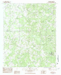 1982 Edgemoor1983 Print · USGSChester and York counties come together in the early eighties as rural life revolves around the Fishing Creek drainage. Researchers can trace family roots through the many local landmarks including Lando, Rodman, and Mt Holly Ch.
 - 1982 Map of Lowrys, 1983 Print
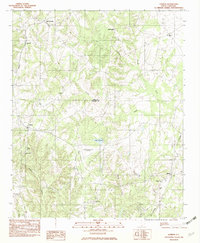 1982 Lowrys1983 Print · USGSNorthern Chester County is captured in the early eighties as a landscape of rural parishes and quiet rail lines. Genealogists can trace family landmarks like Zion Cem, Browns Chapel, and the community of Brattonsville along the SOUTHERN railroad.
 - 1986 Map of Spartanburg
 1986 Spartanburg1986 Print · USGSUpstate South Carolina is captured here in the mid-1980s, showcasing the region's transition from a textile-driven rail corridor to a modern interstate hub. Researchers can trace the legacy of the SOUTHERN railroad through mill towns like Glendale or explore the wooded reaches of the Sumter National Forest.2 unique versions available
 - 1986 Map of Lancaster
 1986 Lancaster1986 Print · USGSThe Carolina borderlands are captured in the mid-1980s as a thriving corridor of rail towns and diverse geography. Researchers can trace the region's heritage through landmarks like Forty Acre Rock, the Southern RR line, and rural sites such as Heath Springs Church.2 unique versions available
End of results
Showing maps 1-4 of 4
Top cities of Chester County
- Chester historical maps
- Great Falls historical maps
- Fort Lawn historical maps
- Richburg historical maps
- Lowrys historical maps
Frequently asked questions
- What are the different types of historical maps available for Chester County?
- What is the oldest map of Chester County?
- Where can I purchase historical maps of Chester County for my home or office?
- Where can I download high-res historical maps of Chester County?
- Are there historical topographic maps available for Chester County?
- Is there historical aerial imagery available for Chester County?
- Where are historical maps of Chester County sourced from?