1970s Maps of Darlington County, South Carolina
Explore 9 historic maps of Darlington County from the 1970s. These maps offer a rare glimpse into what life looked like during the 1970s — showing old roads, neighborhoods, homes, and landmarks that have changed or disappeared over time.
Whether you're researching your family's past, planning a metal detecting trip, or studying how Darlington County's landscape evolved across the 1970s, these high-resolution maps are a powerful tool for exploring the history of this region.
- Focus on a specific era: All maps on this page are from the 1970s, giving you a focused view of this time period.
- See what’s changed: Compare century-old streets, trails, and buildings to today's modern landscape using overlays and satellite layers.
- Research with precision: Use these maps for genealogy, historical research, land use analysis, or educational projects.
- View, download, or print: Maps are fully viewable online in high resolution, and can be downloaded or printed for your own records.
Start exploring Darlington County's history through authentic maps from the 1970s. This is your window into the past.
Darlington County, SC maps
(9)- 1970 Map of Bethune, 1975 Print
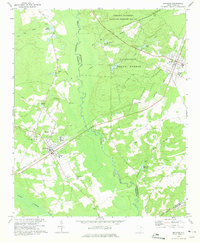 1970 Bethune1975 Print · USGSThe rural sandhills of Kershaw and Chesterfield counties come into focus during the early seventies, centered on the railroad towns of Bethune and McBee. Genealogists can locate family landmarks like Sandy Level Cem, Providence Ch, and old sites like Hough Millpond.
 - 1970 Map of Lucknow, 1975 Print
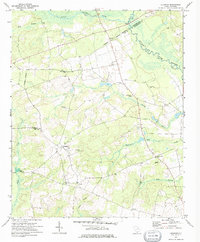 1970 Lucknow1975 Print · USGSThe rural Lee County countryside comes into focus in the early 1970s, showing a landscape shaped by the Lynches River and scattered farming settlements. Genealogists can locate family landmarks like St Matthews Ch, Bethany Cem, and the quiet hamlet of Lucknow.
 - 1971 Map of Society Hill, 1977 Print
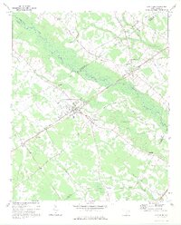
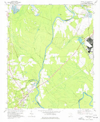 1971 Society Hill1977 Print · USGSSociety Hill and the surrounding river lowlands are captured here in the early seventies as a hub of rail and river transit. Genealogists and local historians can trace family sites at St Marks Ch, the Rosenwald Sch, and the old community of Cash.
 - 1972 Map of Cash, 1973 Print
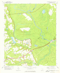
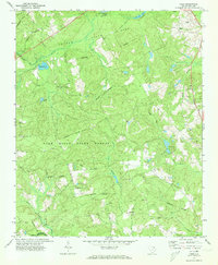 1972 Cash1973 Print · USGSChesterfield and Darlington counties are captured here in the early seventies, showing a landscape of managed state forests and quiet rural crossroads. Genealogists can trace family connections at Macedonia Ch and Piney Grove Cem, while researchers can find the historic Old Wire Rd and the Seaboard Coast Line tracks.
 - 1972 Map of Drake, 1975 Print
 1972 Drake1975 Print · USGSMarlboro County rural life in the early seventies centered on the river bottoms and crossroads communities along the Pee Dee River. Researchers can locate family landmarks such as Cedar Falls Ch, Blenheim Sch, and the settlement of Drake.
 - 1972 Map of Bennettsville South, 1976 Print
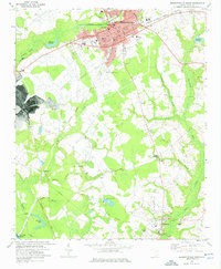 1972 Bennettsville South1976 Print · USGSBennettsville and the southern Marlboro County countryside are shown in detail during the early 1970s. Genealogists and researchers can trace family-named sites such as Driggers Chapel, McCall Cem, and Covington Millpond across this river-and-rail landscape.
 - 1972 Map of Witherspoon Island, 1976 Print
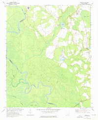
 1972 Witherspoon Island1976 Print · USGSThe Pee Dee River lowlands come to life in the early 1970s, showcasing the intricate water systems surrounding Witherspoon Island. Researchers can trace local family landmarks near Blacks, including Century Ch and Cem, or locate industrial sites like the Fish Hatchery.2 unique versions available
 - 1973 Map of Elliott, 1974 Print
 1973 Elliott1974 Print · USGSIn the early 1970s, the Lee County interior centered on a network of traditional rural hubs and church-centered communities. Researchers can trace family-named sites like Mattie Js Pond or locate historic congregations such as St Sinai Ch and Unionville Ch.2 unique versions available
 - 1973 Map of Lynchburg, 1975 Print
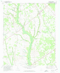
 1973 Lynchburg1975 Print · USGSLynchburg and the surrounding rural communities thrive along the banks of the Lynches River in the early seventies. Genealogists and historians can trace family roots at St Matthews Ch, locate the Hawkins Cem, or follow the path of the Old Stagecoach Road.
End of results
Showing maps 1-9 of 9
Top cities of Darlington County
- Hartsville historical maps
- Darlington historical maps
- Lamar historical maps
- Society Hill historical maps
Frequently asked questions
- What are the different types of historical maps available for Darlington County?
- What is the oldest map of Darlington County?
- Where can I purchase historical maps of Darlington County for my home or office?
- Where can I download high-res historical maps of Darlington County?
- Are there historical topographic maps available for Darlington County?
- Is there historical aerial imagery available for Darlington County?
- Where are historical maps of Darlington County sourced from?