1990s Maps of Coward, South Carolina
Explore 2 historic maps of Coward from the 1990s. These maps offer a rare glimpse into what life looked like during the 1990s — showing old roads, neighborhoods, homes, and landmarks that have changed or disappeared over time.
Whether you're researching your family's past, planning a metal detecting trip, or studying how Coward's landscape evolved across the 1990s, these high-resolution maps are a powerful tool for exploring the history of this region.
- Focus on a specific era: All maps on this page are from the 1990s, giving you a focused view of this time period.
- See what’s changed: Compare century-old streets, trails, and buildings to today's modern landscape using overlays and satellite layers.
- Research with precision: Use these maps for genealogy, historical research, land use analysis, or educational projects.
- View, download, or print: Maps are fully viewable online in high resolution, and can be downloaded or printed for your own records.
Start exploring Coward's history through authentic maps from the 1990s. This is your window into the past.
Coward, SC maps
(2)- 1990 Map of Scranton
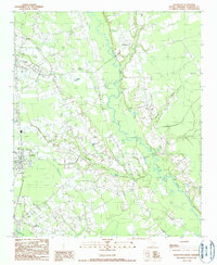 1990 Scranton1990 Print · USGSFlorence County life in the early nineties is centered on the railroad corridor and the wetlands of the Lynches River. Genealogists and local historians can trace family roots through several Cem locations and the settlements of Scranton, Coward, and Friendfield.
 - 1990 Map of Mill Bay
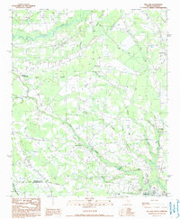 1990 Mill Bay1990 Print · USGSThe Florence and Williamsburg county line comes alive in the 1990s as a landscape of agricultural settlements and distinctive Carolina Bays. Genealogists and local historians can trace family locations near Lake City, Byrds Crossroads, and along the banks of Lynches River.
End of results
Showing maps 1-2 of 2
Top cities near Coward
- Florence historical maps
- Lake City historical maps
- Timmonsville historical maps
- Pamplico historical maps
- Scranton historical maps
- Olanta historical maps
Frequently asked questions
- What are the different types of historical maps available for Coward?
- What is the oldest map of Coward?
- Where can I purchase historical maps of Coward for my home or office?
- Where can I download high-res historical maps of Coward?
- Are there historical topographic maps available for Coward?
- Is there historical aerial imagery available for Coward?
- Where are historical maps of Coward sourced from?