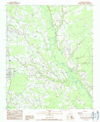
1990 Map of Scranton
USGS Topo · Published 1990About this map
The town of Scranton serves as a focal point in this Florence County landscape, situated near the southwestern corner of a region defined by the winding course of the Lynches River. Moving north, the settlement of Coward marks the upper reaches of the map, while Friendfield and Burkett Landing provide historical reference points along the river's eastern banks. The terrain features a mix of managed water systems, including a notable Drainage Canal and the Millpond Branch, reflecting the agricultural and topographical management of the late 20th century.
Find a feature on this map
11 named features on this map. Tap any name to fly to it.
Don’t see what you’re looking for? This feature index may not catch every label — zoom into the map to look around manually.
Map Details
Editions of this 1990 Scranton Map
This is the sole edition of this map. No revisions or reprints were ever made.
Other maps of this area

1940 · Florence West
USGS Topo · 1:62,500

1940 · Florence East
USGS Topo · 1:62,500

1945 · Florence East
USGS Topo · 1:62,500

1945 · Florence West
USGS Topo · 1:62,500

1946 · Hyman
USGS Topo · 1:62,500

1946 · Lake City
USGS Topo · 1:62,500

1949 · Georgetown
USGS Topo · 1:250,000

1953 · Florence
USGS Topo · 1:250,000

1954 · Florence
USGS Topo · 1:250,000

1967 · Georgetown
USGS Topo · 1:250,000