1900s (20th Century) Maps of Springdale Place, South Carolina
Explore 6 historic maps of Springdale Place from the 1900s (20th Century). These maps offer a rare glimpse into what life looked like during the 1900s — showing old roads, neighborhoods, homes, and landmarks that have changed or disappeared over time.
Whether you're researching your family's past, planning a metal detecting trip, or studying how Springdale Place's landscape evolved across the 1900s, these high-resolution maps are a powerful tool for exploring the history of this region.
- Focus on a specific era: All maps on this page are from the 1900s, giving you a focused view of this time period.
- See what’s changed: Compare century-old streets, trails, and buildings to today's modern landscape using overlays and satellite layers.
- Research with precision: Use these maps for genealogy, historical research, land use analysis, or educational projects.
- View, download, or print: Maps are fully viewable online in high resolution, and can be downloaded or printed for your own records.
Start exploring Springdale Place's history through authentic maps from the 1900s. This is your window into the past.
Springdale Place, SC maps
(6)- 1940 Map of Florence West
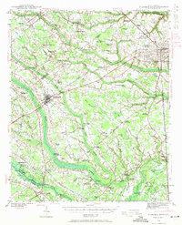 1940 Florence West1940 Print · USGSThe rural landscapes and rail towns west of Florence appear here just before the mid-century, as the local economy revolved around the river and the tracks. Genealogists can trace family roots through numerous country churches like Snow Hill Ch and old settlements like Timmonsville and Ebenezer.2 unique versions available
 - 1945 Map of Florence West
 1945 Florence West1945 Print · USGSInland South Carolina during the mid-1940s is defined here by the converging rails of the Atlantic Coast Line and a network of rural crossroads. Researchers can trace ancestral locations through dozens of landmarks like Anderson Cem, Muldrow Mill, and Syracuse.2 unique versions available
 - 1953 Map of Florence, 1964 Print
 1953 Florence1964 Print · USGSThe Carolina borderlands in the mid-fifties were a landscape of vast river swamps and rising rail towns. Trace the legacy of the Seaboard Air Line through Florence or explore the wetlands surrounding Lake Waccamaw and the Green Swamp.3 unique versions available
 - 1954 Map of Florence
 1954 Florence1954 Print · USGSThe Carolinas borderlands come alive in the early fifties, showing the vital rail-and-river networks of the coastal plain. Genealogists can trace family footprints across the Green Swamp or through settlements like Red Springs, Chadbourn, and McColl.
 - 1983 Map of Florence, 1985 Print
 1983 Florence1985 Print · USGSThe Pee Dee region in the early eighties shows a landscape shaped by river commerce and rail expansion. Researchers can trace historic river crossings at Galivants Ferry or locate vanished rail stops like Willow Creek Siding and Blue Brick.
 - 1986 Map of Florence West, 1987 Print
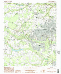 1986 Florence West1987 Print · USGSThe Florence area in the mid-eighties showcases a period of significant suburban expansion and institutional development. Researchers can trace the growth of local neighborhoods like Windsor Forest or locate ancestral sites at the National Cem and Sunset Memory Gardens Cem.2 unique versions available
End of results
Showing maps 1-6 of 6
Top cities near Springdale Place
- Florence historical maps
- Hartsville historical maps
- Darlington historical maps
- Timmonsville historical maps
- Lamar historical maps
- Quinby historical maps
See more
Frequently asked questions
- What are the different types of historical maps available for Springdale Place?
- What is the oldest map of Springdale Place?
- Where can I purchase historical maps of Springdale Place for my home or office?
- Where can I download high-res historical maps of Springdale Place?
- Are there historical topographic maps available for Springdale Place?
- Is there historical aerial imagery available for Springdale Place?
- Where are historical maps of Springdale Place sourced from?