1960s Maps of Slater-Marietta, South Carolina
Explore 3 historic maps of Slater-Marietta from the 1960s. These maps offer a rare glimpse into what life looked like during the 1960s — showing old roads, neighborhoods, homes, and landmarks that have changed or disappeared over time.
Whether you're researching your family's past, planning a metal detecting trip, or studying how Slater-Marietta's landscape evolved across the 1960s, these high-resolution maps are a powerful tool for exploring the history of this region.
- Focus on a specific era: All maps on this page are from the 1960s, giving you a focused view of this time period.
- See what’s changed: Compare century-old streets, trails, and buildings to today's modern landscape using overlays and satellite layers.
- Research with precision: Use these maps for genealogy, historical research, land use analysis, or educational projects.
- View, download, or print: Maps are fully viewable online in high resolution, and can be downloaded or printed for your own records.
Start exploring Slater-Marietta's history through authentic maps from the 1960s. This is your window into the past.
Slater-Marietta, SC maps
(3)- 1960 Map of Knoxville
 1960 Knoxville1960 Print · USGSThe Southern Appalachians come alive in the 1950s, showing the intersection of new national park tourism and deep-rooted mountain industry. Trace old rail lines like the Clinchfield RR and find high-altitude landmarks from Mt Le Conte to the Cherokee Indian Reservation.2 unique versions available
 - 1961 Map of Cleveland, 1963 Print
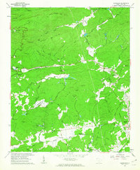 1961 Cleveland1963 Print · USGSThe Greenville and Pickens county line comes into focus in the early sixties as a region of mountain retreats and river-valley settlements. Researchers can trace family ties at the South Saluda Ch Cem or explore mid-century landmarks like Camp Marietta and Caesars Head.2 unique versions available
 - 1964 Map of Knoxville
 1964 Knoxville1964 Print · USGSThe Southern Appalachians and Great Smokies are captured here during the mid-sixties, showing the rugged borderlands of Tennessee and North Carolina. Researchers can trace historic mountain routes like U S 441, the expanse of Pisgah National Forest, and the growing footprints of Asheville and Knoxville.
End of results
Showing maps 1-3 of 3
Top cities near Slater-Marietta
- Greenville historical maps
- Greer historical maps
- Mauldin historical maps
- Easley historical maps
- Wade Hampton historical maps
- Brevard historical maps
See more
Top neighborhoods of Slater-Marietta
Frequently asked questions
- What are the different types of historical maps available for Slater-Marietta?
- What is the oldest map of Slater-Marietta?
- Where can I purchase historical maps of Slater-Marietta for my home or office?
- Where can I download high-res historical maps of Slater-Marietta?
- Are there historical topographic maps available for Slater-Marietta?
- Is there historical aerial imagery available for Slater-Marietta?
- Where are historical maps of Slater-Marietta sourced from?