1950s Maps of Greer, South Carolina
Explore 7 historic maps of Greer from the 1950s. These maps offer a rare glimpse into what life looked like during the 1950s — showing old roads, neighborhoods, homes, and landmarks that have changed or disappeared over time.
Whether you're researching your family's past, planning a metal detecting trip, or studying how Greer's landscape evolved across the 1950s, these high-resolution maps are a powerful tool for exploring the history of this region.
- Focus on a specific era: All maps on this page are from the 1950s, giving you a focused view of this time period.
- See what’s changed: Compare century-old streets, trails, and buildings to today's modern landscape using overlays and satellite layers.
- Research with precision: Use these maps for genealogy, historical research, land use analysis, or educational projects.
- View, download, or print: Maps are fully viewable online in high resolution, and can be downloaded or printed for your own records.
Start exploring Greer's history through authentic maps from the 1950s. This is your window into the past.
Greer, SC maps
(7)- 1954 Map of Greenville, 1965 Print
 1954 Greenville1965 Print · USGSThe Upstate and Northeast Georgia are captured here during a decade of massive transformation as new reservoirs reshaped the Piedmont. Genealogists and hikers can trace the Appalachian Trail over Brasstown Bald or locate old community centers like Demorest, Westminster, and Royston.3 unique versions available
 - 1955 Map of Knoxville
 1955 Knoxville1955 Print · USGSThe Southern Appalachians and the Smoky Mountains are shown here at a peak of mid-century development and conservation. Genealogists and historians can trace the early road networks connecting Gatlinburg, Waynesville, and the Cherokee Indian Reservation across the high ridges.
 - 1957 Map of Greer, 1959 Print
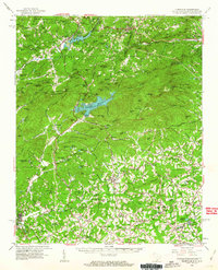
 1957 Greer1959 Print · USGSThe Upstate South Carolina textile corridor comes to life in this mid-century survey of the Tyger River valleys. Researchers can trace the industrial footprint of Victor Mills, locate early country churches like Old Pilgrim Ch, and explore the residential growth around Greer and Lyman.2 unique versions available
 - 1957 Map of Greenville, 1959 Print
 1957 Greenville1959 Print · USGSGreenville and its industrial suburbs are captured during a period of rapid mid-century expansion and military prominence. Genealogists and historians can locate established mill communities like Monaghan, the sprawling Donaldson Air Force Base, and the campuses of Furman University and Bob Jones University.
 - 1957 Map of Knoxville, 1966 Print
 1957 Knoxville1966 Print · USGSThe Southern Appalachians of Tennessee and North Carolina are mapped here during the mid-twentieth century as new highways reached the high country. Genealogists and historians can trace the topography between Knoxville and Asheville, locating family landmarks near Fontana Lake or along the Blue Ridge Parkway.4 unique versions available
 - 1958 Map of Greenville
 1958 Greenville1958 Print · USGSThe Piedmont and Blue Ridge foothills come alive in this mid-century survey of the Upstate and Northeast Georgia. Trace the regional rail-and-river economy through the Southern Railway corridors and early reservoir developments like Lake Sidney Lanier.
 - 1959 Map of Tigerville, 1963 Print
 1959 Tigerville1963 Print · USGSThe Carolina borderlands come into focus in the late fifties as the Blue Ridge foothills balance mountain industry and rural education. Researchers can trace the Southern railroad line through Tuxedo or locate local landmarks like North Greenville Junior College and Berrys Millpond.2 unique versions available
End of results
Showing maps 1-7 of 7
Top cities near Greer
- Greenville historical maps
- Mauldin historical maps
- Simpsonville historical maps
- Wade Hampton historical maps
- Lyman historical maps
- Piedmont historical maps
See more
Top neighborhoods of Greer
- Maplewood historical maps
- Victor Heights historical maps
- Burgiss Hills historical maps
- King Acres historical maps
- Maple historical maps
- The Cottages at Brushy Creek historical maps
See more
Frequently asked questions
- What are the different types of historical maps available for Greer?
- What is the oldest map of Greer?
- Where can I purchase historical maps of Greer for my home or office?
- Where can I download high-res historical maps of Greer?
- Are there historical topographic maps available for Greer?
- Is there historical aerial imagery available for Greer?
- Where are historical maps of Greer sourced from?