1910s Maps of Hampton County, South Carolina
Explore 6 historic maps of Hampton County from the 1910s. These maps offer a rare glimpse into what life looked like during the 1910s — showing old roads, neighborhoods, homes, and landmarks that have changed or disappeared over time.
Whether you're researching your family's past, planning a metal detecting trip, or studying how Hampton County's landscape evolved across the 1910s, these high-resolution maps are a powerful tool for exploring the history of this region.
- Focus on a specific era: All maps on this page are from the 1910s, giving you a focused view of this time period.
- See what’s changed: Compare century-old streets, trails, and buildings to today's modern landscape using overlays and satellite layers.
- Research with precision: Use these maps for genealogy, historical research, land use analysis, or educational projects.
- View, download, or print: Maps are fully viewable online in high resolution, and can be downloaded or printed for your own records.
Start exploring Hampton County's history through authentic maps from the 1910s. This is your window into the past.
Hampton County, SC maps
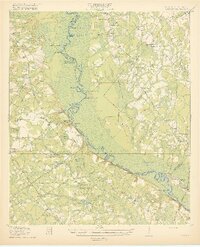
(6)- 1918 Map of Varnville
 1918 Varnville1918 Print · USGSCoastal South Carolina is depicted just after the Great War, showing a network of rail-dependent towns and timber operations. Genealogists can trace family roots through numerous local landmarks like Prince William Church, Hampton, and Harrison Sawmill.4 unique versions available
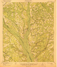
 - 1918 Map of Yemassee
 1918 Yemassee1918 Print · USGSCoastal South Carolina at the end of the Great War reveals a landscape of tidal rivers and emerging rail junctions. Genealogists can trace family locations across Grahams Neck or near historic sites like Pocotaligo, Sheldon, and the logging camps around Gilmania.4 unique versions available
 - 1919 Map of Pineland
 1919 Pineland1919 Print · USGSThe Lowcountry landscape of Jasper and Hampton counties is captured here at the end of the post-war era, showing a transition between rail-centered towns and timber-rich wetlands. Genealogists can locate family ties at Highsmith's Sawmill, Good Hope Church, and the Pineland Club.3 unique versions available
 - 1919 Map of Olar
 1919 Olar1919 Print · USGSBamberg and Barnwell counties are shown here just after the Great War, when the river swamps still dictated the path of travel. Genealogists can locate family sites near Hushes Old Mill, Savannah Creek Church, and Stony Bay School.3 unique versions available
 - 1919 Map of Shirley
 1919 Shirley1919 Print · USGSThe Savannah River borderlands in the years following the Great War reveal a landscape of active river landings, logging railroads, and tight-knit rural communities. You can trace early 20th-century family roots at Heavenly Rest Ch, Cypressvale School, and the busy Hudsons Ferry Landing.3 unique versions available
 - 1919 Map of Cummings
 1919 Cummings1919 Print · USGSThe Lowcountry borderlands of Hampton and Colleton counties are captured here just after the Great War, showing a landscape of river-swamps and timber rail lines. Genealogists can trace family roots through dozens of local landmarks like Annie Laurie Church, Ricepatch School, and Bells Crossroads.3 unique versions available
End of results
Showing maps 1-6 of 6
Top cities of Hampton County
- Hampton historical maps
- Estill historical maps
- Varnville historical maps
- Yemassee historical maps
- Blountville historical maps
- Brunson historical maps
See more
Frequently asked questions
- What are the different types of historical maps available for Hampton County?
- What is the oldest map of Hampton County?
- Where can I purchase historical maps of Hampton County for my home or office?
- Where can I download high-res historical maps of Hampton County?
- Are there historical topographic maps available for Hampton County?
- Is there historical aerial imagery available for Hampton County?
- Where are historical maps of Hampton County sourced from?