1950s Maps of Lugoff, South Carolina
Explore 3 historic maps of Lugoff from the 1950s. These maps offer a rare glimpse into what life looked like during the 1950s — showing old roads, neighborhoods, homes, and landmarks that have changed or disappeared over time.
Whether you're researching your family's past, planning a metal detecting trip, or studying how Lugoff's landscape evolved across the 1950s, these high-resolution maps are a powerful tool for exploring the history of this region.
- Focus on a specific era: All maps on this page are from the 1950s, giving you a focused view of this time period.
- See what’s changed: Compare century-old streets, trails, and buildings to today's modern landscape using overlays and satellite layers.
- Research with precision: Use these maps for genealogy, historical research, land use analysis, or educational projects.
- View, download, or print: Maps are fully viewable online in high resolution, and can be downloaded or printed for your own records.
Start exploring Lugoff's history through authentic maps from the 1950s. This is your window into the past.
Lugoff, SC maps
(3)- 1953 Map of Lugoff, 1957 Print
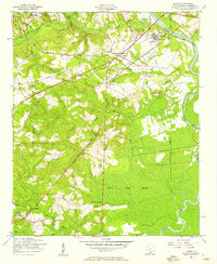 1953 Lugoff1957 Print · USGSKershaw County in the mid-fifties shows a landscape of rail-driven industry and rural community life near the Wateree River. Genealogists and historians can trace family-named sites like Porter Cemetery, the Green Hill School, and the abandoned gravel washer.
 - 1953 Map of Blaney, 1957 Print
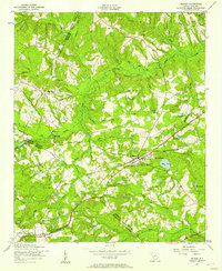 1953 Blaney1957 Print · USGSRichland and Kershaw Counties come together in the early fifties near the rail town of Blaney. Researchers can trace old family footprints at Shady Grove Cem, find the historic Bethel Camp Ground, or locate rural landmarks like Bookman's Mill.
 - 1953 Map of Spartanburg, 1966 Print
 1953 Spartanburg1966 Print · USGSMid-century South Carolina comes into focus through this survey of the Piedmont and the Sand Hills at a time of significant reservoir expansion. Researchers can trace the legacy of industrial transit and resource extraction from the Haile Gold Mine to the rail hubs of the Seaboard Air Line.4 unique versions available
End of results
Showing maps 1-3 of 3
Top cities near Lugoff
Top neighborhoods of Lugoff
- The Groves historical maps
- Thunderwoods historical maps
- Woodland Forest historical maps
- Gettysburg historical maps
- Mayfield Acres historical maps
- Pecan Orchard historical maps
See more
Frequently asked questions
- What are the different types of historical maps available for Lugoff?
- What is the oldest map of Lugoff?
- Where can I purchase historical maps of Lugoff for my home or office?
- Where can I download high-res historical maps of Lugoff?
- Are there historical topographic maps available for Lugoff?
- Is there historical aerial imagery available for Lugoff?
- Where are historical maps of Lugoff sourced from?