1980s Maps of Norris Heights, South Carolina
Explore 2 historic maps of Norris Heights from the 1980s. These maps offer a rare glimpse into what life looked like during the 1980s — showing old roads, neighborhoods, homes, and landmarks that have changed or disappeared over time.
Whether you're researching your family's past, planning a metal detecting trip, or studying how Norris Heights's landscape evolved across the 1980s, these high-resolution maps are a powerful tool for exploring the history of this region.
- Focus on a specific era: All maps on this page are from the 1980s, giving you a focused view of this time period.
- See what’s changed: Compare century-old streets, trails, and buildings to today's modern landscape using overlays and satellite layers.
- Research with precision: Use these maps for genealogy, historical research, land use analysis, or educational projects.
- View, download, or print: Maps are fully viewable online in high resolution, and can be downloaded or printed for your own records.
Start exploring Norris Heights's history through authentic maps from the 1980s. This is your window into the past.
Norris Heights, SC maps
(2)- 1986 Map of Camden South
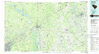 1986 Camden South1986 Print · USGSThe South Carolina midlands come into focus in the mid-eighties, showing the sprawling corridors between the Wateree and Lynches Rivers. Genealogists and historians can trace family roots through numerous mill sites and rural junctions like Boykin, Lucknow, and Hermitage Mill Pond.4 unique versions available
 - 1988 Map of Camden North
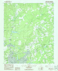 1988 Camden North1988 Print · USGSKershaw County at the close of the 1980s reveals the northern growth of the historic city of Camden into the surrounding pine-tree creek bottoms. Genealogists and local researchers can trace the edges of Hermitage, locate Woodward Field, and explore the marshes of N R Goodale State Park.2 unique versions available
End of results
Showing maps 1-2 of 2
Top cities near Norris Heights
- Columbia historical maps
- Lugoff historical maps
- Camden historical maps
- Elgin historical maps
- Bethune historical maps
Frequently asked questions
- What are the different types of historical maps available for Norris Heights?
- What is the oldest map of Norris Heights?
- Where can I purchase historical maps of Norris Heights for my home or office?
- Where can I download high-res historical maps of Norris Heights?
- Are there historical topographic maps available for Norris Heights?
- Is there historical aerial imagery available for Norris Heights?
- Where are historical maps of Norris Heights sourced from?